Africa Maps
africa maps — pre-owned
Browse 39 africa maps — pre-owned on eBay — listings updated every few minutes. All items are pre-owned and sold by eBay sellers directly.

Belgian Congo pictorial mid-century tourist poster map by James Thiriar 1950
'Belgian Congo'. CAPTION BELOW PICTURE: 'Belgian Congo'. Printed by Léon Beyaert-Sioen, Courtrai/Kortrijk.

French Equatorial and Begian Congo - 1942 Vintage WW2 Serial Map Service Map
A very attractive map, originally extracted from an original Serial Map Service Subscription publication. see photo. Two binding holes to one edge.

20th Century Vintage French Nautical Map - “Cote Ouest Afrique”
20th Century Vintage French Nautical Map - “Cote Ouest Afrique” (Northwest Africa). Includes Tenerife, Lanzarote.

French Africa - 1940 Vintage WW2 Serial Map Service Map
A very attractive map, originally extracted from an original Serial Map Service Subscription publication. see photo. Two binding holes to one edge.
![[North Africa]—Egypt—Libya—Tunisia—Algeria—Antique Ottoman Arabic map 1909](https://i.ebayimg.com/images/g/rVcAAeSwUjZqKbvc/s-l500.jpg)
[North Africa]—Egypt—Libya—Tunisia—Algeria—Antique Ottoman Arabic map 1909
It was introduced in the Vilayet Law of 21 January 1867. Late-Ottoman era Arabic language regional map, 1909. TYPE: Late-Ottoman era Arabic language regional map. CAPTION BELOW PICTURE: '[North Africa]'.

MOROCCO. Mapa de la Zona de Influencia Espanola en Marruecos 1913 old
DATE PRINTED: 1913. PROVENANCE: "Atlas de Espana", Bailly-Bailliere - Riera, Publicado por la Sociedad Anonima Anuarios Bailly-Bailliere y Riera Reunidos., Barcelona. CONDITION: Fair: Verso text apparent.

Middle Eastern Oil—Major Oil Companies—persuasive map—Richard Edes Harrison 1947
Richard Edes Harrison, Middle Eastern Oil, double-page map from Fortune, May 1947. The map’s colour blocks expose corporate and imperial claims—ARAMCO, Iraq Petroleum, Anglo-Iranian, Kuwait Oil and others—cutting across political borders.
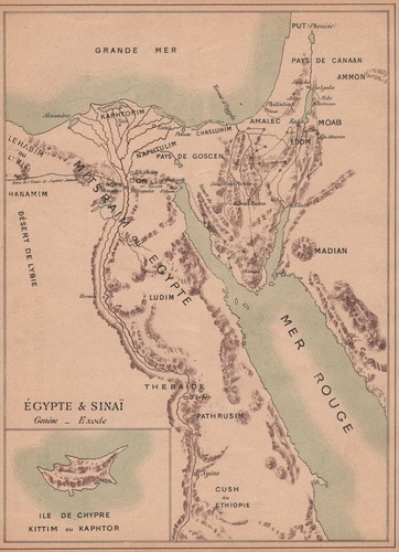
BIBLICAL EGYPT. Egypt & Sinaï Sinai. Cyprus Chypre Kittim Kaphtor 1887 old map
'Égypte & Sinaï; Inset map of Ile de Chypre Kittim ou Kaphtor'. TITLE OF MAP: 'Égypte & Sinaï; Inset map of Ile de Chypre Kittim ou Kaphtor'. Antique colour map, 1887. DATE PRINTED: 1887. CONDITION: Good; suitable for framing.

ALGERIA. Operation Torch assault, Oran 7-8 Nov 1942 1956 old vintage map chart
Operation "Torch" the assault on Oran 7-8 November 1942'. CAPTION BELOW PICTURE: 'Map 35. This map was published in 1956 but it may depict an earlier representation of the area shown dated 1942 and the mapmaker may have drawn on an earlier original work.

Southeast to Asia—Persuasive map—World War 2—Richard Edes Harrison—Fortune 1944
PROVENANCE: "Look at the World—A Fortune Atlas for World Strategy", by Richard Edes Harrison, text by the editors of Fortune. New York: Alfred A. Knopf. Harrison credits Britain’s “experienced geographical sense” in committing scarce military resources to the region early in the war.
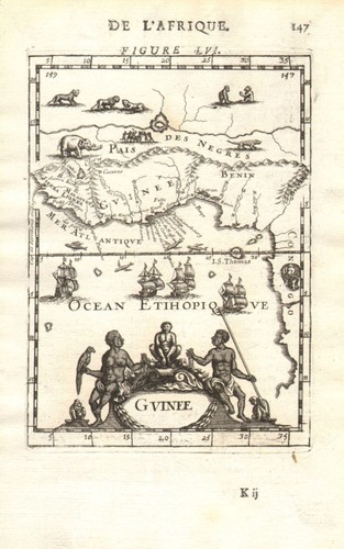
WEST AFRICA. Guinea. Nigeria Ghana Benin Togo Sierra Leone. MALLET 1683 map
Original 17th century copperplate map, 1683. DATE PRINTED: 1683. St Thomas island. CONDITION: Good; suitable for framing. The map you will receive is in good condition but there may be minor variations in the condition from that shown in the image.

Carte Officielle Paris Match—Paris-Dakar rallye. Poster route map 57x45cm 1989
PROVENANCE: Paris Match. DATE PRINTED: 1989.

Kilimanjaro Safari map. Arusha Amboseli Tsavo Nairobi Mount Kenya Tanzania 1952
[3-4] South A37 - Kilimanjaro. CAPTION BELOW PICTURE: '[3-4] South A37 - Kilimanjaro'. DATE PRINTED: Compiled 1941. Revised edition January 1951. Reprinted 1952. CONDITION: Good; suitable for framing.

ANTIQUE 1759 ENGRAVING MAP OF THE COUNTRIES BORDERING ON THE RIVERS SANAGRA &
Date: 1759. Antique copper plate engraving is toned with several small punctures in the right margin including one within the engraving in the lower right corner but clean and in very good condition.
You save $18.74

Freetown. Sierra Leone. South Senegambia 1885 old antique map plan chart
'Freetown'. TITLE OF MAP: 'Freetown'. Antique wood-engraved map. Scale 1:195,000, 1885. DATE PRINTED: 1885. CONDITION: Good; suitable for framing. VERSO: There are images and/or text printed on the reverse side of the picture.

Sport-Auto—9e Rallye Paris-Dakar—Peugeot Talbot—56 x 42 cm poster route map 1987
'Sport-auto—9e Rallye Paris-Dakar 1er-22 Janvier 1987'. CAPTION BELOW PICTURE: 'Sport-auto—9e Rallye Paris-Dakar 1er-22 Janvier 1987'. AUTHENTICITY: This is an authentic historic print, published at the date stated above.

Southern Africa Railway & Index Map. Rhodesia Bechuanaland. SAMLER BROWN 1914
Twentieth edition. J.C. Juta & Co., Cape Town, Port Elizabeth, and Johannesburg. CAPTION BELOW PICTURE: 'Railway and Index Map'. 'Railway and Index Map'. Antique colour map, 1914. DATE PRINTED: 1914.

Asia Minor & Persia. Middle East. Turkey Iran Iraq Arabia. THE TIMES 1895 map
'Asia Minor and Persia'. CAPTION BELOW PICTURE: 'Asia Minor and Persia'. Antique colour atlas map, 1895. DATE PRINTED: 1895. AUTHENTICITY: This is an authentic historic print, published at the date stated above.

The Middle East—World War 2 regional map—Richard Edes Harrison—Fortune 1942
Original folds, as issued; light handling. PROVENANCE: Fortune Magazine. DATE PRINTED: November 1942. AUTHENTICITY: This is an authentic historic print, published at the date stated above. It is not a modern copy.

EAST AFRICA. Eritrea Abyssinia British Italian French Somaliland Aden 1920 map
'Eritrea, Abyssinia & Somaliland; Inset map of Straits of Bab-el–Mandeb; Indian ocean'. CAPTION BELOW PICTURE: 'Eritrea, Abyssinia & Somaliland; Inset map of Straits of Bab-el–Mandeb; Indian ocean'. DATE PRINTED: 1920.

RGS East African Expedition to Lakes Nyassa & Tanganyika—Joseph Thomson 1880 map
A key RGS East African Expedition map. He reached Lake Tanganyika and helped clarify the geography of the great lakes and their outlets. Antique Royal Geographical Society map with related text pages, 1880.

Part of East Africa. Scott Elliott. Uganda Rwanda Tanzania Burundi. RGS 1895 map
'Map of Part of East Africa to illustrate a paper by G F Scott Elliott MA'. CAPTION BELOW PICTURE: 'Map of Part of East Africa to illustrate a paper by G F Scott Elliott MA'. Antique Royal Geographical Society map, 1895.
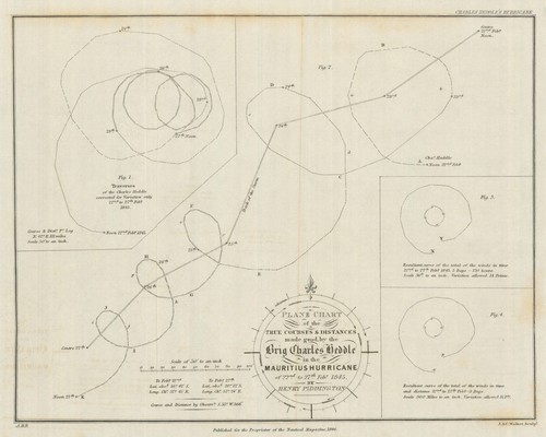
True Courses & Distances of the Brig Charles Heddle…Mauritius Hurricane 1846 map
Antique engraved map, 1846. DATE PRINTED: 1846. John and Charles Walker Sc. TYPE: Antique engraved map.

ARABIA. Bahrain UAE Mecca Medina Oman Qatar 'Arabie'. MALLET 1683 old map
'Arabie' (De L'Asie). TITLE OF THE MAP: 'Arabie'. Original 17th century copperplate map, 1683. DATE PRINTED: 1683. CONDITION: Good; suitable for framing. The map you will receive is in good condition but there may be minor variations in the condition from that shown in the image.

Rhodesia… British South Africa Company. Game reserves. Zimbabwe Zambia 1910 map
PROVENANCE: "Rhodesia. Antique colour map, 1910. DATE PRINTED: October 1910.

SENEGAL. Senegal; Republic of Senegal 1973 old vintage map plan chart
'Senegal; Republic of Senegal'. TITLE OF MAP: 'Senegal; Republic of Senegal '. Scale 1/3,000,000, 1973. DATE PRINTED: 1973. CONDITION: Good; suitable for framing. Verso text quite apparent. Scale 1/3,000,000.

MEDITERRANEAN. Tunisia/Libyan coast. Sicily. Gulf of Sirte. BARTHOLOMEW 1944 map
'Tunisia and Libyan Coast'. TITLE OF MAP: 'Tunisia and Libyan Coast'. Scale 1: 5,000,000, 1944. DATE PRINTED: 1944. This map was printed in an atlas that was published during the Second World War.

Lesotho. Lesotho 1885 old antique vintage map plan chart
Antique wood-engraved map. Scale 1:2;000;000, 1885. DATE PRINTED: 1885. CONDITION: Good; suitable for framing. VERSO: There are images and/or text printed on the reverse side of the picture. TYPE: Antique wood-engraved map.

Vintage Dubai town city plan, United Arab Emirates. UAE. GEOprojects 2003 map
CAPTION BELOW PICTURE: 'Dubai'. DATE PRINTED: 2003.

'Plan du Fort Anglois de Commendo'. Ft Komenda, Ghana Gold Coast BELLIN 1747 map
Antique copperplate map, 1747. DATE PRINTED: 1747. CONDITION: Good; suitable for framing. The map you will receive is in good condition but there may be minor variations in the condition from that shown in the image.

Geological Map of the Country between… in Southern Rhodesia—Zimbabwe 1933
PROVENANCE: Southern Rhodesia Geological Survey. Geological mapping under the direction of Dr. J. Austen Bancroft. Large antique colour geological map, 1933. TYPE: Large antique colour geological map.
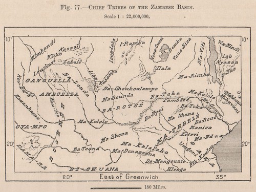
Chief Tribes of the Zambezi Basin. Zambia Mozambique 1885 old antique map
'Chief Tribes of the Zambese Basin'. TITLE OF MAP: 'Chief Tribes of the Zambese Basin'. Antique wood-engraved map. Scale 1:22;000;000, 1885. DATE PRINTED: 1885. CONDITION: Good; suitable for framing.

10e Rallye Paris-Dakar Paris Match Motorsport poster route map 46x58cm 1988
'10e Rallye Paris-Alger-Dakar 1988 - Kouros - Paris Match - La Cinq'. CAPTION BELOW PICTURE: '10e Rallye Paris-Alger-Dakar 1988 - Kouros - Paris Match - La Cinq'. PROVENANCE: Paris Match. VERSO: There is related information printed on the reverse side.

Congo Free State & river valley. Central Africa. HENRY MORTON STANLEY 1885 map
This large map shows the Congo River basin and Great Lakes of the African Rift Valley in great detail. The borders of the Congo Free State, declared the year of publication of the map, are shown. The map is taken from the Swedish language edition of "The Congo and the founding of its free state: a story of work and exploration.".
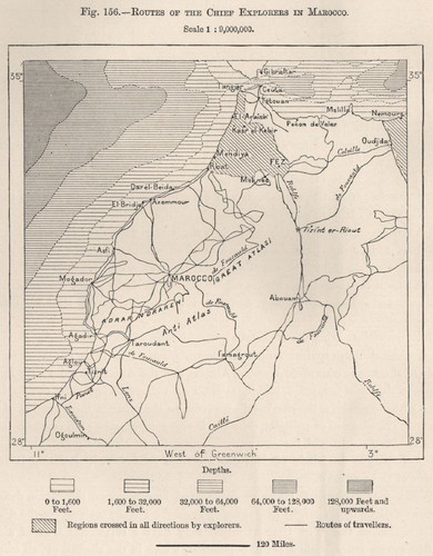
Routes of the chief explorers in Marocco. Morocco 1885 old antique map chart
Antique wood-engraved map. Scale 1:9,000,000, 1885. DATE PRINTED: 1885. CONDITION: Good; suitable for framing. VERSO: There are images and/or text printed on the reverse side of the picture. TYPE: Antique wood-engraved map.

Routes of the chief explorers in Fezzan. Libya 1885 old antique map plan chart
Antique wood-engraved map. Scale 1:700,000, 1885. DATE PRINTED: 1885. CONDITION: Good; suitable for framing. VERSO: There are images and/or text printed on the reverse side of the picture. TYPE: Antique wood-engraved map.

Routes of explorers in the Chad Basin. Chad. The Chad Basin 1885 old map
Antique wood-engraved map. Scale 1:12,000,000, 1885. DATE PRINTED: 1885. CONDITION: Good; suitable for framing. TYPE: Antique wood-engraved map. Scale 1:12,000,000. VERSO: There are images and/or text printed on the reverse side of the picture.

Trade Routes and Projected Railways in Senegal. Mali 1885 old antique map
Antique wood-engraved map. Scale 1:16,000,000, 1885. DATE PRINTED: 1885. CONDITION: Good; suitable for framing. VERSO: There are images and/or text printed on the reverse side of the picture. TYPE: Antique wood-engraved map.

BOAC AIRLINE ROUTE MAP 1949 SECTION 1 BRITAIN TO MIDDLE EAST B.O.A.C.
OK condition, with wear, small mark to cover.