Asia Maps
asia maps — pre-owned
Browse 2,683 asia maps — pre-owned on eBay — listings updated every few minutes. All items are pre-owned and sold by eBay sellers directly.

HONG KONG 1915 Kowloon Original Antique Vintage map China 1915 map 香港 Kow-loon
Map printed in March 1915 describing city for international tourists. HONG KONG in 1914. 16.5 cm x 16 cm.

HANKOU 1915 Wuchang Hanyang WUHAN 武汉市 ORIGINAL Vintage map plan Hubei Hankow
HANKOU Wuchang Hanyang WUHAN. printed 1915.

1917 Operations off the Coast of Palestine - 1931 Antique Admiralty WW1 Map
Original Antique map extracted from a 1931 Report on activity and operations during WW1. Map is in very good condition, with general light creasing along folds, but nothing major see photo. General light handling creases to edges.

C. 1850 MAP OF PALESTINE AND JERUSALEM c. 1850
Date: 1850.
You save $47.49

HONG KONG 1915 Original Antique map China 1915 map 香港
Map printed in March 1915 describing city for international tourists. HONG KONG in 1914. 44.5 cm x 16 cm.

'Shang-pu (trading quarter), Chi-nan'. Jinan antique city plan. China 1915 map
Shang-pu (Trading quarter), Chi-nan [Jinan]. TITLE OF MAP: 'Shang-pu (Trading quarter), Chi-nan [Jinan]'. Antique colour town city plan, 1915. DATE PRINTED: 1915. TYPE: Antique colour town city plan. AUTHENTICITY: This is an authentic historic print, published at the date stated above.

City plan of Shanghai & its suburbs about 1853 by William Charles Milne 1921 map
'Shanghai and its suburbs, about 1853'. CAPTION BELOW PICTURE: 'Shanghai and its suburbs, about 1853'. PROVENANCE: "The History of Shanghai" by G. Lanning & S. Couling. Printed and published for the Shanghai Municipal Council by Kelly & Walsh, Limited, Shanghai—Hongkong—Singapore—Hankow—Yokohama, 1921.
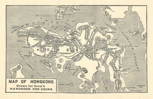
Sketch map of Hong Kong by Carl Crow 1921 old antique vintage plan chart
PROVENANCE: "The Travelers' Handbook for China (including Hongkong)" by Carl Crow. Third edition, revised. Carl Crow, Shanghai. 'Map of Hong Kong - drawn for Crow's "Handbook for China"'. CAPTION BELOW PICTURE: 'Map of Hong Kong - drawn for Crow's "Handbook for China"'.
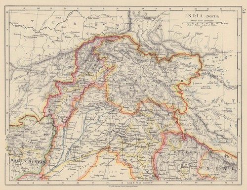
BRITISH INDIA NORTH. Jammu Kashmir Punjab Himalayas. JOHNSTON 1910 old map
PROVENANCE: "The World Wide Atlas of Modern Geography Political and Physical"; by J. Scott Keltie; Published by W. & A. K. Johnston, Edinburgh & London. 7th Edition (revised) [World wide atlas]. Colour antique map, 1910.
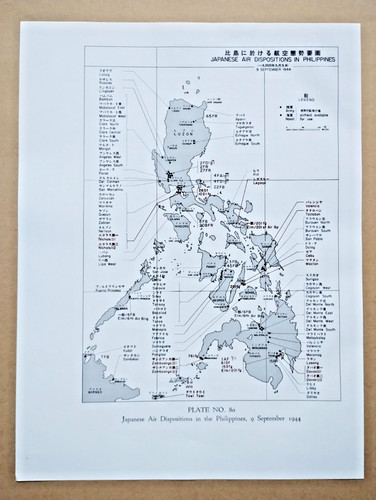
Japanese Dispositions in the Philippines in September 1944- 1967 Vintage WW2 Map
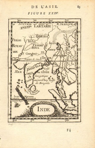
SOUTH ASIA. India Ceylon Sri Lanka Indochina Maldives. 'Inde'. MALLET 1683 map
The map encompasses the whole of India & Indochina including Burma, Thailand, Malaysia/Singapore and South East Asia. The Maldive islands are shown. 'Inde' (De L'Asie). TITLE OF THE MAP: 'Inde'. Original 17th century copperplate map, 1683.

'Idée de l'Isle de Java'. Indonesia. Dutch East India Co. VOC. BELLIN 1750 map
Antique copperplate map, 1750. DATE PRINTED: 1750. Idée de l'Isle de Java, tirée des Manuscrits Hollandois [Map of the Island of Java taken from Dutch manuscripts]. CAPTION BELOW PICTURE: 'Idée de l'Isle de Java, tirée des Manuscrits Hollandois [Map of the Island of Java taken from Dutch manuscripts]'.

Asia by Herman Moll. Great Wall of China. Mogol empire. Tartaria 1701 old map
Antique copperplate map, 1701. DATE PRINTED: 1701. The Great Wall of China is indicated. CONDITION: Good; suitable for framing. Tight right margin. TYPE: Antique copperplate map.

Luzon, Philippines - 1945 Vintage WW2 Serial Map Service Map
A very attractive map, originally extracted from an original Serial Map Service Subscription publication. see photo. Two binding holes to one edge with a little light browning to the holes.

The Philippines - 1944 Vintage WW2 Serial Map Service Map
A very attractive map, originally extracted from an original Serial Map Service Subscription publication. see photo.
1944 Very Large (58.5 x 38.75 in) NavWar Map No. 5 World War II Western Pacific
The present map is independently cataloged among the holdings of roughly fifteen institutions in the OCLC and appears occasionally on the market. The “island-hopping” strategy – bypassing heavily fortified Japanese positions to seize strategically important islands – proved decisive in advancing Allied forces toward Japan.

"First plan of British consular buildings & grounds", Shanghai c.1843– 1921 map
Because the sheet is still wholly projective, its prototype was probably drawn no later than 1846–48. 'First plan of British consular buildings and grounds'. CAPTION BELOW PICTURE: 'First plan of British consular buildings and grounds'.

Persia, Afghanistan, Baluchistan, Turkey. South west Asia. STANFORD 1904 map
'Persia with parts of Afghanistan, Baluchistan, Turkey in Asia, &c.'. CAPTION BELOW PICTURE: 'Persia with parts of Afghanistan, Baluchistan, Turkey in Asia, &c.'. PROVENANCE: "Stanford's London Atlas of Universal Geography", folio edition.

Overland trade routes from India & Burma to China. Coryton/RGS 1875 old map
Compiled by J. Coryton, engraved by Edward Weller. 31.5 × 35.5 cm (12.5 × 14 in). Engraved by Edward Weller. Antique Royal Geographical Society map with related text pages, 1875. DATE PRINTED: 1875.

Battle of Singapore. Town city. 12th to 15th February 1942 1957 old map
DATE PRINTED: 1957. PROVENANCE: "The War against Japan. Her Majesty's Stationery Office, London. CONDITION: Good; suitable for framing.
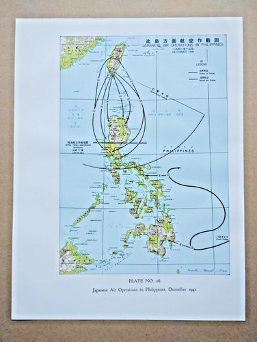
Japanese Air Operations in the Philippines, December 1941 - 1967 Vintage WW2 Map

Hebron / al-Khalil antique town city plan. Israel. West Bank 1912 old map
'Hebron (El-Khalil)'. TITLE OF MAP: 'Hebron (El-Khalil)'. Antique tourist map, 1912. DATE PRINTED: 1912. CONDITION: Good; suitable for framing. TYPE: Antique tourist map. VERSO: There is nothing printed on the reverse side, which is plain.

China from the direction of Guam—Persuasive map—WW2—Richard Edes Harrison 1941
Richard Edes Harrison, China: Chung Hua Min Kuo, “seen from the direction of Guam”, published April 1941. Invaded China has retreated inland, but its vast terrain, dispersed people, guerrillas and improvised military communications keep it fighting and challenging Japanese occupation.
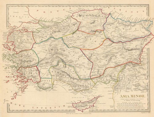
ASIA MINOR ANCIENT. Turkey. Cappadocia Cyprus Galatia Phrygia. SDUK 1844 map
Antique steel engraved map with original outline hand colouring (coloring), 1844. DATE PRINTED: This map was originally published by Baldwin & Cradock in 1830; this date is printed on the map. This edition of the map was printed and published by Chapman & Hall in 1844.

BORNEO & THE PHILIPPINE ISLANDS. East Indies. Manila Zebu/Cebu. WELLER 1863 map
'Borneo; The Philippine Islands'. TITLE OF MAP: 'Borneo; The Philippine Islands'. Antique map with original outline colour, 1863. DATE PRINTED: 1863. CONDITION: Good; suitable for framing. The map you will receive is in good condition but there may be minor variations in the condition from that shown in the image.

CASPIAN SEA.Baku Persia(Iran)Astrakhan.Inner Kirghiz Horde.JOHNSTON 1906 map
'Caspian Sea'. TITLE OF MAP: 'Caspian Sea'. PROVENANCE: "The Victoria Regina Atlas"; Published by W & A.K. Johnston, Ltd, Edinburgh & London: 2nd Edition. Antique colour map, 1906. DATE PRINTED: 1906.

Fourteenth Army Plan of Attack - Bataan Philippines - 1967 Vintage WW2 Map
Slight light crease to top left corner.
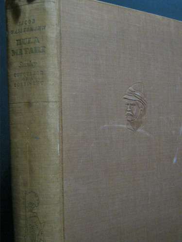
ANTIQUE -BULA MATARI (HENRY M. STANLEY)- CONQUEROR OF A CONTINENT- AFRICA - 1933
BULA MATARI. Conqueror Of A Continent. HENERY M. STANLEY. Antique Book.

The East China Sea - 1944 Vintage WW2 Serial Map Service Map
A very attractive map, originally extracted from an original Serial Map Service Subscription publication. see photo. Two binding holes to one edge.

Summary of Japanese Movements in Eastern New Guinea - 1967 Vintage WW2 Map
Light crease to top left corner.

Map TOURIST MAP OF TOKYO 1891 printed in full colours
Tourist Map of Tokyo 1891. Full title: Tourist Map of Tokyo 1891. We believe the date of publication is July 1891 and while we have seen similar copies, they rarely contain the surrounding marginal images in colour.

Bataan, Second Phase Operations in 1942 (Philippines) - 1967 Vintage WW2 Map
Slight light crease to top right corner.

Sea of Marmara & adjacent region. Northwest Turkey. 51x65cm STANFORD 1904 map
'The Sea of Marmara'. CAPTION BELOW PICTURE: 'The Sea of Marmara'. PROVENANCE: "Stanford's London Atlas of Universal Geography", folio edition. London, Edward Stanford, Geographer to Her Majesty. Large (folio) antique atlas map, 1904.

Kedah. Japanese invasion of Malaya. December 1941 1957 old vintage map chart
CAPTION BELOW PICTURE: 'Kedah'. DATE PRINTED: 1957. CONDITION: Good; suitable for framing. AUTHENTICITY: This is an authentic historic print, published at the date stated above. It is not a modern copy.

Japanese assault on Singapore Island, 11th February 1942 1957 old vintage map
'Operations on Singapore Island, 11th February 1942'. CAPTION BELOW PICTURE: 'Operations on Singapore Island, 11th February 1942'. DATE PRINTED: 1957. PROVENANCE: "The War against Japan. Her Majesty's Stationery Office, London.

FRENCH INDOCHINA. N Laos & Annam. Vietnam. Tourane (Da Nang) city plan 1929 map
'Laos et Annam - Politique (nord). Inset: Tourane'. CAPTION BELOW PICTURE: 'Laos et Annam - Politique (nord). DATE PRINTED: 1929. CONDITION: Good; suitable for framing. The map you will receive is in good condition but there may be minor variations in the condition from that shown in the image.

ISRAEL. Jerusalem, sketch map c1885 old antique vintage plan chart
Antique engraved sketch map. Scale 1: 25,000, c1885. DATE PRINTED: c1885. 'Fig. 192 Jerusalem'. TITLE OF THE MAP: 'Fig. 192 Jerusalem'. TYPE: Antique engraved sketch map. Scale 1: 25,000. CONDITION: Good; suitable for framing.

Plan of Hong Kong & City of Victoria by Carl Crow. China 1933 old vintage map
PROVENANCE: "Handbook for China (including Hongkong)" by Carl Crow. Fifth edition, revised throughout. Carl Crow, Shanghai. 'Plan of Hong Kong - City of Victoria - drawn for Crow's "Handbook for China"'.

Operations of Guadalcanal between August & November 1942 - 1967 Vintage WW2 Map
Slight light crease to top right corner.
