Central America/Caribbean Maps
central america/caribbean maps — pre-owned
Browse 690 central america/caribbean maps — pre-owned on eBay — listings updated every few minutes. All items are pre-owned and sold by eBay sellers directly.

EARLY - Map - Cuba Habana Native Maiden Tobacco Antique Cigar Box Label SR.L.mC
Antique Original -Cuba / Habana - (NOT Embossed !). Lithograph Cigar Box Label. Produced in Havana, Cuba, by "Litog. Compañía Litográfica de la Habana", as noted by the tiny printer signature. tobacco lithography in Cuba.

1898 Spanish American War Print - Large Color Map Of Cuba & Vicinity Countries
FROM THE 1898 BOOK "HARPER'S PICTORIAL HISTORY OF THE WAR WITH SPAIN".BY MAJOR GENERAL NELSON A. MILES. "MAP OF CUBA AND SURROUNDING AREA". THESE PRINTS INVOLVE THE CARIBBEAN OR PACIFIC AREAS OF THE WAR.CUBA, PUERTO RICO OR THE PHILIPPINES.ETC.

Trinidad & Tobago. Cocoa, sugar cane & coconut plantations. Oil fields 1938 map
'Map of Trinidad & Tobago shewing the administrative divisions and distribuition of agricultural and mineral products'. CAPTION BELOW PICTURE: 'Map of Trinidad & Tobago shewing the administrative divisions and distribuition of agricultural and mineral products'.

The Bahamas, Cuba & Bermuda "or Summer Islands". THOMSON 1817 old antique map
Antique early 19th century atlas map with original hand colouring, 1817. DATE PRINTED: Published in 1817. Engraved in 1816; this date is marked on the map. 'Chart of the Bahama Islands. Island of Cuba'.

"L'Isle de Cuba", the southern Bahamas and the Florida Keys. BONNE 1780 map
Antique copperplate engraved map, 1780. DATE PRINTED: 1780. A map of Cuba, the southern Bahamas and the Florida Keys. 'L'Isle de Cuba'. TITLE OF MAP: 'L'Isle de Cuba'.

Archipel des Antilles—West Indies Caribbean Iles du Vent 1817 old antique map
Archipel des Antilles [West Indies Archipelago]. CAPTION BELOW PICTURE: 'Archipel des Antilles [West Indies Archipelago]'. Antique copperplate map, 1817. DATE PRINTED: 1817. PROVENANCE: "Victoires, conquêtes, désastres, revers et guerres civiles, des français" Published by C.L.F. Panckoucke, Paris [Victoires & désastres des français].

Bay Islands. Honduras. Central America 1885 old antique vintage map plan chart
Antique wood-engraved map. Scale 1:1,500,000, 1885. DATE PRINTED: 1885. TITLE OF MAP: 'Bay Islands'. CONDITION: Good; suitable for framing. 'Bay Islands'. VERSO: There are images and/or text printed on the reverse side of the picture.

Tobago. Trinidad and Tobago 1885 old antique vintage map plan chart
TITLE OF MAP: 'Tobago'. Antique wood-engraved map. Scale 1:470,000, 1885. DATE PRINTED: 1885. CONDITION: Good; suitable for framing. VERSO: There are images and/or text printed on the reverse side of the picture.

Bimini Island and Banks. Bahamas 1885 old antique vintage map plan chart
Antique wood-engraved map. Scale 1:950,000, 1885. DATE PRINTED: 1885. TITLE OF MAP: 'Bemini Island and Banks'. 'Bemini Island and Banks'. CONDITION: Good; suitable for framing. VERSO: There are images and/or text printed on the reverse side of the picture.

TRINIDAD. Vintage map. West Indies. Caribbean 1914 old antique plan chart
PROVENANCE: "The Pocket Guide to The West Indies"; Edited by Algeron E. Aspinall; Published by Duckworth & Co., London: 3rd Edition. 'Trinidad'. TITLE OF MAP: 'Trinidad'. DATE PRINTED: 1914. CONDITION: Good; suitable for framing.

CUBA. Vintage map. Inset Puerto Rico. West Indies. Caribbean 1927 old
PROVENANCE: "The Pocket Guide to The West Indies"; by Algernon Aspinall, published by Sifton, Praed & Co., Ltd., London. DATE PRINTED: 1927. CONDITION: Good; suitable for framing. The map you will receive is in good condition but there may be minor variations in the condition from that shown in the image.

CUBA & JAMAICA. Bahamas, Cayman Islands & Florida Keys. ETTLING 1863 old map
Antique map with original outline colour, 1863. 'Cuba and Jamaica'. TITLE OF MAP: 'Cuba and Jamaica'. DATE PRINTED: 1863. CONDITION: Good; suitable for framing. The map you will receive is in good condition but there may be minor variations in the condition from that shown in the image.

NEW PROVIDENCE. Vintage map. Bahamas. Caribbean 1935 old vintage chart
'Island of New Providence, Bahamas'. TITLE OF MAP: 'Island of New Providence, Bahamas'. DATE PRINTED: 1935. CONDITION: Good; suitable for framing. The map you will receive is in good condition but there may be minor variations in the condition from that shown in the image.

TRINIDAD. Vintage map. West Indies. Caribbean 1935 old vintage plan chart
PROVENANCE: "The Pocket Guide to The West Indies"; by Algernon Aspinall, published by Sifton, Praed & Co., Ltd., London. 'Trinidad; Inset map of Tobago'. TITLE OF MAP: 'Trinidad; Inset map of Tobago'.
Map of Cuba with Sea monster by Sebastian Munster 1572 old antique chart
Antique 16th century woodcut map, 1572. DATE PRINTED: 1572. CAPTION BELOW PICTURE: 'Cuba'. CONDITION: Good; suitable for framing. TYPE: Antique 16th century woodcut map. VERSO: There is Latin text and/or images printed on the reverse side.

Trinidad. Trinidad and Tobago 1885 old antique vintage map plan chart
Antique wood-engraved map. Scale 1:1,300,000, 1885. 'Trinidad'. TITLE OF MAP: 'Trinidad'. DATE PRINTED: 1885. CONDITION: Good; suitable for framing. VERSO: There are images and/or text printed on the reverse side of the picture.

Trinidad & Tobago showing parishes, wards & steamer routes. Waterlow 1919 map
'Trinidad & Tobago'. CAPTION BELOW PICTURE: 'Trinidad & Tobago'. Antique colour map, 1919. DATE PRINTED: 1919.

Cubae & Iamaicae /Cuba Insula by Bertius/Langenes. Cuba Jamaica Caymans 1603 map
Descriptio Cubae et Iamaicae / Cuba Insula [Cuba, Jamaica & the Cayman Islands]. CAPTION BELOW PICTURE: 'Descriptio Cubae et Iamaicae / Cuba Insula [Cuba, Jamaica & the Cayman Islands]'. Engraved by Petrus Kaerius (Pieter van den Keere).

"YLAND OF BARBADOS". Plantations. After Ligon 1657. West Indies 1931 old map
'Richard Ligon's map of Barbados published in 1657'. TITLE OF MAP: 'Richard Ligon's map of Barbados published in 1657'. PROVENANCE: "The Pocket Guide to The West Indies"; by Algernon Aspinall, published by Sifton, Praed & Co., Ltd., London.

WEST INDIES. Dominica St Kitts Antigua St Lucia Montserrat 1914 old map
PROVENANCE: "The Pocket Guide to The West Indies"; Edited by Algeron E. Aspinall; Published by Duckworth & Co., London: 3rd Edition. DATE PRINTED: 1914. CONDITION: Good; suitable for framing.

CARIBBEAN ANTIQUE & MODERN MAP COLLECTION
1-ISLES ANTILLES Antique Map - Pierre Duval, Paris c1660 Copper engraving with original hand colouring. Published by Thomson,London, 1828 Paper size 34x27cm Map size 29.7x40.7cm Very good condition3-ISLES ANTILLES Antique Map - Pierre Duval, Paris c1660 Copper engraving.

WEST INDIES. Dominica St Kitts Antigua St Lucia Montserrat 1910 old map
PROVENANCE: "The Pocket Guide to The West Indies"; Edited by Algeron E. Aspinall; Published by Duckworth & Co., London: New and revised [2nd] edition. DATE PRINTED: 1910. CONDITION: Good; suitable for framing.
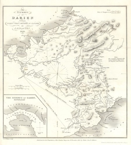
Isthmus of Darien between Porto Velo, Chagres & Panama—John Aug. Lloyd 1832 map
By J. A. Lloyd, F.R.S. 1829.'. Commissioned in 1827 by Simón Bolívar, following an introduction from Sir Robert Ker Porter, Lloyd surveyed the territory of Gran Colombia to assess the feasibility of linking the Atlantic and Pacific.

South America 1885 old antique vintage map plan chart
Antique colour map. Scale 1:15,000,000, 1885. DATE PRINTED: 1885. TYPE: Antique colour map. Scale 1:15,000,000. CONDITION: Good; suitable for framing. VERSO: There is nothing printed on the reverse side, which is plain.

Lines of Navigation & Submarine Cables in the West Indies 1885 old antique map
Antique wood-engraved map. Scale 1:32,000,000, 1885. DATE PRINTED: 1885. CONDITION: Good; suitable for framing. VERSO: There are images and/or text printed on the reverse side of the picture. TYPE: Antique wood-engraved map.

WEST INDIES. Greater Antilles. Cuba Hispaniola Bahamas 1907 old antique map
'West Indies: Greater Antilles'. CAPTION BELOW PICTURE: 'West Indies: Greater Antilles'. Colour antique map. Scale 1:5,000,000, 1907. DATE PRINTED: 1907. TYPE: Colour antique map. Scale 1:5,000,000.
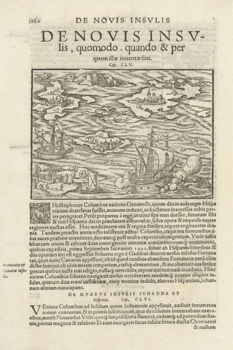
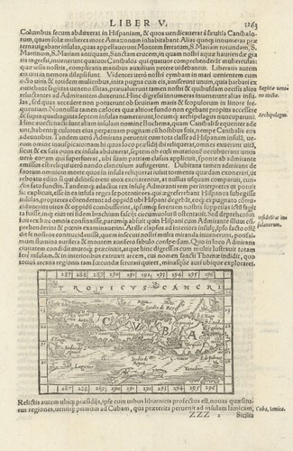
De Novis lnsulis... Columbus amid the New (Caribbean) Islands. MÜNSTER 1572 map
Antique 16th century woodcut map, 1572. DATE PRINTED: 1572. AUTHENTICITY: This is an authentic historic print, published at the date stated above. It is not a modern copy. TYPE: Antique 16th century woodcut map.

Battle of St. Kitts, Jan-Feb 1782, Caribbean — Sir Samuel Hood—2 sheets 1824 map
Untitled antique engraved naval battle plans (2 map sheets) and explanatory text pages (original, except for two text sheets in facsimile), 1824. DATE PRINTED: 1824. TYPE: Untitled antique engraved naval battle plans (2 map sheets) and explanatory text pages (original, except for two text sheets in facsimile).
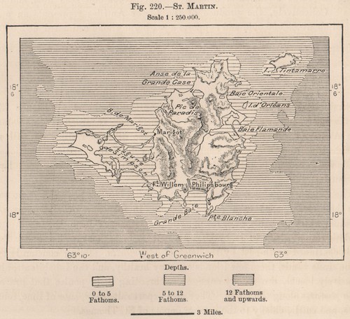
St. Martin. West Indies. The Lesser Antilles 1885 old antique map plan chart
Antique wood-engraved map. Scale 1:250,000, 1885. DATE PRINTED: 1885. CONDITION: Good; suitable for framing. VERSO: There are images and/or text printed on the reverse side of the picture. TYPE: Antique wood-engraved map.

PORT OF SPAIN. Vintage map. Trinidad. West Indies. Caribbean 1931 old
PROVENANCE: "The Pocket Guide to The West Indies"; by Algernon Aspinall, published by Sifton, Praed & Co., Ltd., London. 'Part of Port of Spain, Trinidad'. TITLE OF MAP: 'Part of Port of Spain, Trinidad'.

Map of Jamaica showing counties, parishes & railways by Edward Stanford 1919
CAPTION BELOW PICTURE: 'Jamaica'. Antique colour map, 1919. DATE PRINTED: 1919. TYPE: Antique colour map. AUTHENTICITY: This is an authentic historic print, published at the date stated above. It is not a modern copy.

SOUTH AMERICA. North-west; map of Galapagos Isles 1907 old antique chart
Colour antique map, 1907. DATE PRINTED: 1907. TYPE: Colour antique map. CONDITION: Good; suitable for framing. VERSO: There are images and/or text printed on the reverse side of the picture.

BRITISH/US VIRGIN ISLANDS Tortola Virgin Gorda St Croix St Thomas/John 1935 map
DATE PRINTED: 1935. CONDITION: Good; suitable for framing. The map you will receive is in good condition but there may be minor variations in the condition from that shown in the image. AUTHENTICITY: This is an authentic historic print, published at the date stated above.

ST VINCENT, GRENADA & THE GRENADINES. Lesser Antilles. West Indies 1927 map
PROVENANCE: "The Pocket Guide to The West Indies"; by Algernon Aspinall, published by Sifton, Praed & Co., Ltd., London. DATE PRINTED: 1927. CONDITION: Good; suitable for framing. The map you will receive is in good condition but there may be minor variations in the condition from that shown in the image.

French West Indies. Guadeloupe Marie-Galante St. Martin St. Barthélemy 1890 map
Original antique hand-coloured engraved map. DATE PRINTED: 1890. TYPE: Original antique hand-coloured engraved map. AUTHENTICITY: This is an authentic historic print, published at the date stated above.

Interoceanic Waterparting, Honduras. Central America 1885 old antique map
'Interoceanic Waterparting, Honduras'. TITLE OF MAP: 'Interoceanic Waterparting, Honduras'. Antique wood-engraved map. Scale 1:480,000, 1885. DATE PRINTED: 1885. CONDITION: Good; suitable for framing.

Anguilla St. Martin/Maarten Barts. Caribbean. US Navy sea chart 1899 (1917) map
Large US Navy nautical sea chart. DATE PRINTED: Surveyed 1847. Published 1899. Corrections to 1917. TYPE: Large US Navy nautical sea chart. PROVENANCE: Washington, D.C., Published at the Hydrographic Office, under the authority of the Secretary of the Navy.

Johnson's West Indies. Bermuda Islands. Caribbean Bahamas 1865 old antique map
'Johnson's West Indies // The Bermuda Islands'. CAPTION BELOW PICTURE: 'Johnson's West Indies // The Bermuda Islands'. Large, decorative hand coloured 19th century atlas map, 1865. DATE PRINTED: 1865.

Port of Spain. Trinidad and Tobago 1885 old antique vintage map plan chart
Antique wood-engraved map. Scale 1:115,000, 1885. DATE PRINTED: 1885. VERSO: There are images and/or text printed on the reverse side of the picture. TITLE OF MAP: 'Port of Spain'. 'Port of Spain'. CONDITION: Good; suitable for framing.

Disputed Terr. Haiti Santo Domingo. Hispaniola. Hispaniola 1885 old map
'Disputed territory between Haiti and San Domingo'. TITLE OF MAP: 'Disputed territory between Haiti and San Domingo'. Antique wood-engraved map. Scale 1:7,000,000, 1885. DATE PRINTED: 1885. CONDITION: Good; suitable for framing.