Europe Maps
europe maps — pre-owned
Browse 24,774 europe maps — pre-owned on eBay — listings updated every few minutes. All items are pre-owned and sold by eBay sellers directly.

Big Germany Wall Map 4.5 FT Unification Poster 1990 Deutschland School Chart
Big 1990 Wall Map Germany 55" x 39". Size: 55 x 39 in (4.5 FT x 3.3 FT) / 140 x 100 cm. Historic 1st Map produced of newly reunified Germany in 1990. October 3, 1990 was the end of a divided Germany. Printed in 1990 by Inter Nationes of Bonn, Germany.

1928 N.C. Wyeth Art Print - "Beyond Uncharted Seas Columbus Finds A New World"
BUY IT FOR A GIFT FOR THAT ART ENTHUSIAST.

1928 N.C. Wyeth Art Print - "Map Of Discovery, Eastern Hemisphere" - C MY OTHERS
BUY IT FOR A GIFT FOR THAT ART ENTHUSIAST.

View of Sluis, Jan Caspar Philips, After Abraham de Haen, 1740 Flemish Engraving
From From Isaak Tirion - The Present State of the United Netherlands.

'The Islands of Corsica & Sardinia'. Elba. JOHN DOWER. Dispatch Atlas 1862 map
'The Islands of Corsica and Sardinia'. TITLE OF MAP: 'The Islands of Corsica and Sardinia'. Antique map with original outline colour, 1862. DATE PRINTED: 1862. DEUTSCHLAND: Alte Lankarten und Stadt ansichten.

Luxembourg Luxemburg pictorial bird's eye view city plan. #24 BOLLMANN 1960 map
'Luxembourg'. CAPTION BELOW PICTURE: 'Luxembourg'. AUTHENTICITY: This is an authentic historic print, published at the date stated above. It is not a modern copy. CONDITION: Good; suitable for framing.
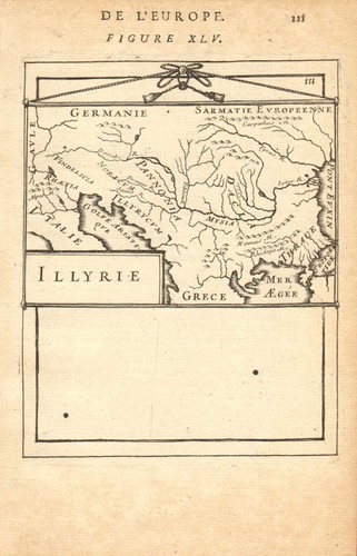
BALKANS. Illyria 'Illyrie'. Danube basin. Pannonia Mysia. MALLET 1683 old map
TITLE OF THE MAP: 'Illyrie'. In classical antiquity, Illyria was a region in the western part of the Balkan Peninsula inhabited by the Illyrians. "Illyria" is thus a designation of a roughly defined region of the western Balkans as seen from a Roman perspective.

Formula 1 French Grand Prix—Clermont Ferrand—circuit event flyer 1972 old map
Punctures caused by volcanic debris and limited run-off made Charade increasingly unsuitable for modern Formula One, which moved to Paul Ricard in 1973. DATE PRINTED: 1972.

Isola di Capri panoramic bird's eye view tourist map by Heinrich Berann c1950
Folding panoramic bird's eye view tourist map, c1950. DATE PRINTED: c1950. 'Isola di Capri'. CAPTION BELOW PICTURE: 'Isola di Capri'. Printed in Italy. Sigla Effe, Genova. TYPE: Folding panoramic bird's eye view tourist map.

SARONIC ISLANDS & KYTHIRA. Aegina Spetses Hydra Poros. Greece. MALLET 1683 map
The map depicts the east Peloponnese coast, the coast of Attica (Athens is shown at the top), Cerigo (Kythira) and the Greek Saronic islands of Ingna (Aegina/Egina), Specie (Spetses), Sidra (Hydra), Damala (Poros), Cecerico (probably Antikythera) & Falconera (probably Antimilos).
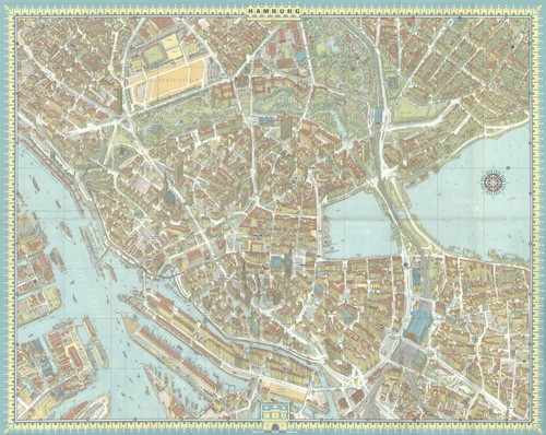
Hamburg pictorial bird's eye view city plan #43 — Bollmann — Bildkart 1964 map
CAPTION BELOW PICTURE: 'Hamburg'. DATE PRINTED: 1964. AUTHENTICITY: This is an authentic historic print, published at the date stated above. It is not a modern copy.

VYSOKE TATRY 1911 Slovensko Original Map Slovakia Hohe Tatra Poland POPRAD
VYSOKE TATRY. Original print. 31.75 cm x 21 cm.

C1908 Plan De Paris par Arrondiiement Maps of Paris for tourists great condition
This is a C1908 Tourist handbook of maps of Paris and surrounding area.Has a handwritten dated March 11,1908.Has large foldout map in back and many smaller maps.In amazing condition.Please see photos.

1918 World War I German Propaganda Map 'U-Bootswirkung im Mittelmeer' U-Boats
The map is designed with a simple yet effective impact on its viewer. On the landmasses, texts in bold red stress that none of the depicted vessels were sunk before February 1st of 1917, and none were dropped by mines.
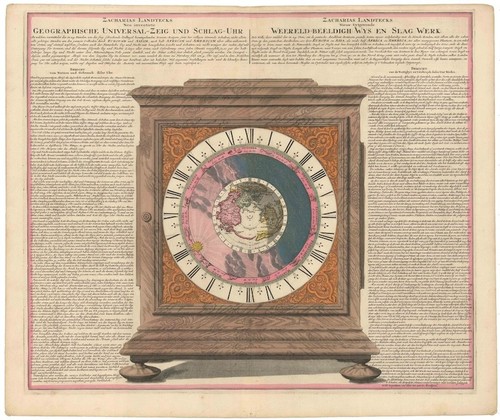
c. 1705 Homann Print of Landteck's Universal Clock Long-lost Enlightenment Work
Landteck's actual universal clock is also an elusive artifact. He instead based much of his research on a replica made in 1738 for Polish King Frederick August III. That changed in 2005, when the Musee International d'Horlogerie in La Chaux-de-Fonds, Switzerland, successfully acquired a copy for its collection.

c. 1940 Early Map of German-Occupied France 'Delimitation de la Zone Occupee'
Delimitation de la Zone Occupee [German Occupation of France]. These events are captured by this map with a dramatic simplicity. We suspect that it was published in 1940 or 1941. Vichy is given no special marking.

IRELAND. Irish Free State. Ulster/Northern Ireland. Counties 1938 old map
Scale 1:1,700,000, 1938. DATE PRINTED: 1938. TITLE OF MAP: 'Ireland '. CONDITION: Good; suitable for framing. Scale 1:1,700,000. VERSO: There are images and/or text printed on the reverse side of the picture.
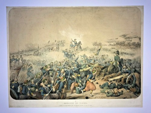
CRIMEA BATTLE OF ALMA 1854 by ADAM VERY LARGE ANTIQUE VIEW 19TH CENTURY
Gagnée sur les Russes par les Armées alliées le 20 7bre 1854". Condition : good condition, a small repair in upper and left side, in colors.

El Hierro, Canary Islands, Spain 1885 old antique vintage map plan chart
TITLE OF MAP: 'Hierro'. Antique wood-engraved map. Scale 1:330,000, 1885. DATE PRINTED: 1885. CONDITION: Good; suitable for framing. VERSO: There are images and/or text printed on the reverse side of the picture.

RUSSIA IN EUROPE SE.Transcaucasia Stavropol Astrakhan Caspian.JW LOWRY 1863 map
Antique map with original outline colour, 1863. DATE PRINTED: 1863. CONDITION: Good; suitable for framing. The map you will receive is in good condition but there may be minor variations in the condition from that shown in the image.

Isle of Skye pictorial map by A. Macphee. Talisker & Rum Whisky 1960 old
The locations of the Battles of Trumpan (1580) and Glenshiel (1719) are marked. 'Isle of Skye'. CAPTION BELOW PICTURE: 'Isle of Skye'. 20th century colour pictorial map, 1960. TYPE: 20th century colour pictorial map.

Arbois et Arbois Mousseux wine vignoble appellation map – Jura – Jura 1946
Arbois [et Arbois Mousseux]. CAPTION BELOW PICTURE: 'Arbois [et Arbois Mousseux]'. Mid-twentieth century wine region sketch map, 1946. DATE PRINTED: 1946. TYPE: Mid-twentieth century wine region sketch map.
![Map of Dublin [for] Sinn Fein Rebellion Handbook. 1916 Easter Rising 1917](https://i.ebayimg.com/images/g/scQAAeSwpuBqKbtP/s-l500.jpg)
Map of Dublin [for] Sinn Fein Rebellion Handbook. 1916 Easter Rising 1917
DATE PRINTED: Easter 1916 [1917 issue].

L’Étoile et L’Étoile Mousseux wine vins appellation map – Jura – Jura 1946
L’Étoile [et L’Étoile Mousseux]. CAPTION BELOW PICTURE: 'L’Étoile [et L’Étoile Mousseux]'. Mid-twentieth century wine region sketch map, 1946. DATE PRINTED: 1946. TYPE: Mid-twentieth century wine region sketch map.

View of Riga, Latvia. SEBASTIAN MÜNSTER 1572 old antique map plan chart
CAPTION BELOW PICTURE: 'Riga'. Antique 16th century woodcut map, 1572. DATE PRINTED: 1572. CONDITION: Good; suitable for framing. TYPE: Antique 16th century woodcut map. AUTHENTICITY: This is an authentic historic print, published at the date stated above.

Plan of London & Westminster shewing 1643 Forts & 1666 Fire damage 1749 map
Antique copperplate map. The complete original explanatory text page will be provided with the map., 1749. DATE PRINTED: 1749. PROVENANCE: "Gentleman's Magazine and Historical Chronicle", by Sylvanus Urban, Gent.

W LONDON. Hammersmith Holland Park Brook Green West Kensington. WELLER 1863 map
Part of Shepherd's Bush Green is shown at the top centre of the map. Holland Park is depicted top right, and Ravenscourt Park centre left. 'Suburbs of London sheet 4. TITLE OF MAP: 'Suburbs of London sheet 4.

FINCHLEY. Church End, Hampstead Garden Suburb, Mill Hill, Hendon 1923 old map
AUTHENTICITY: This is an authentic historic print, published at the date stated above. It is not a modern copy. PROVENANCE: "The Authentic map directory of London and suburbs", first edition, published by Geographia (1923) Ltd [The Authentic map directory of London].

North West Africa: Physical & Strategic- 1941 Vintage WW2 Serial Map Service Map
A very attractive map, originally extracted from an original Serial Map Service Subscription publication. see photo. Two binding holes to one edge.

RARE Antique Swiss Map Lake Thun – Thunersee Bernese Oberland Switzerland
Thunersee, located in the scenic Bernese Oberland region of Switzerland. Region Featured Lake Thun (Thunersee), Bernese Oberland, Canton of Bern, Switzerland. Map Title Likely “Exkursionskarte Thunersee” (Excursion Map of Lake Thun).

WWII Occupation Map of Germany c.1945–46 – Allied Zones – Military Govt Approved
The map shows the Allied occupation zones and is printed in bothEnglish and German.

Original WWII National Fire Service Forestry Map – Chepstow Park Wood & District
A rare large-format map produced by the National Fire Service (NFS) during World War II as part of its forestry fire protection planning. This sheet is part of Forestry Fire Area 20-B and covers Reference: Forestry Fire Area 20 – Division B.

CANARY ISLANDS. Islas Canarias Tenerife Gran C Lanzarote. Spain. MALLET 1683 map
Shows the Canary islands, with Madeira on the horizon. Sea/naval battles. Original 17th century copperplate map, 1683. DATE PRINTED: 1683. TYPE: Original 17th century copperplate map. CONDITION: Good; suitable for framing.

L'Itinéraire du Tour de France - Le Miroir des Sports. Cycling route map 1962
'L'Itinéraire des Tours de France 1962 - But et Club - Le Miroir des Sports'. CAPTION BELOW PICTURE: 'L'Itinéraire des Tours de France 1962 - But et Club - Le Miroir des Sports'. PROVENANCE: But et Club - Le Miroir des Sports.

The Cambridge University Boat Club Bumps rowing course by Edward Weller 1888 map
Antique colour antique map, 1888. DATE PRINTED: 1888. 'The Cambridge Course'. CAPTION BELOW PICTURE: 'The Cambridge Course'. AUTHENTICITY: This is an authentic historic print, published at the date stated above.

LONDON. Vintage Underground / Tube map 1937 old vintage plan chart
CAPTION BELOW PICTURE: 'Map of the Underground railways of London'. 'Map of the Underground railways of London'. DATE PRINTED: 1937. CONDITION: Good; suitable for framing. VERSO: There is another map printed on the reverse side of this map.

Imperium Russiae Magnae. The Russian Empire by Matthäus Seutter c1744 old map
Antique 18th century copperplate map with original wash colour, c1744. Cum Privileg S.R.I. Vicariat. Antique 18th century copperplate map of the Russian Empire by Matthäus Seutter. Tobias Conrad Lotter Sculp.

World War 2. Eastern Front. 23 June-7 Aug 1944 Russian Summer Offensive 1959 map
VERSO: There is another map printed on the reverse side. Antique colour military map, 1959. DATE PRINTED: 1959. DEUTSCHLAND: Alte Lankarten und Stadt ansichten. ITALIA: Stampe e Mappe antiche. ESPAÑA: Mapas antiquos y impresiones antiguas.

WWII NFS Forestry Map – Abercarn & Cwmcarn Woods with Collieries – Monmouthshire
Original WWII National Fire Service Forestry Map – Abercarn, Cwmcarn Woods & Colliery District (Monmouthshire) – Area 20-B. Abercarn, Cwmcarn, Crosskeys, Pont-y-waun. NFS forestry stations at Abercarn and Cwmcarn (checkered square symbols).

Southern European Invasion Coast - 1943 Vintage WW2 Serial Map Service Map
A very attractive map, originally extracted from an original Serial Map Service Subscription publication. see photo.