North America Maps
north america maps — pre-owned
Browse 3,050 north america maps — pre-owned on eBay — listings updated every few minutes. All items are pre-owned and sold by eBay sellers directly.

Antique 1896 Educational Game Geography Maps OUR UNION FIRESIDE GAME CO. 1109 #2
This is deck #2 in a blue and gold box. Deck #1 is in a blue and silver box. CONDITION : Complete with 52 cards and Directions booklet, all of which are in very good condition: gently rubbed and lightly soiled.

Vintage Framed Gold Foil World Map PETER SCHENK Planisphaerium Terrestre 31”x25”
• Reproduction of the historic Planisphaerium Terrestre map. • Overall size: 31” x 25”.

1988 City Designs Pictorial Promotional Map of Santa Cruz, California
At left in the foreground is the Santa Cruz Wharf, which was partially destroyed during a severe storm in December 2024, but has since reopened after repairs were completed on the surviving portion. This view is quite scarce, with only two institutional holdings noted in the OCLC (49499130), located at Stanford University and UC Santa Cruz, and limited market history.

RARE & LARGE 1894 Civil War Lithograph Color Map Print - "Southern States"
PRINT FROM THE 1894 BOOK. "HARPER'S PICTORIAL HISTORY OF THE CIVIL WAR.". GREAT GIFT YOUR MAN CAVE. "PRINT PREPARED FOR HARPER'S PICTORIAL HISTORY OF THE CIVIL WAR. DECEMBER, 1863.".

UNITED STATES. 31 states+Missouri/Western/Nebraska Terr.TALLIS/RAPKIN 1851 map
Antique engraved map by J Rapkin, published by John Tallis. Original outline hand colour, decorative border, and attractive inset vignette views, 1851. Published by John Tallis & Co. TYPE: Antique engraved map by J Rapkin, published by John Tallis.

ORIGINAL 1855 COLTON'S HAND COLORED MAP OF GEORGETOWN & CITY OF WASHINGTON DC
Publisher: J. H. Colton & Co. Date: 1855. Antique hand colored map is toned but clean and in very good condition. 18.5" x 16".

Bear Mountain Park panoramic pictorial tourist map—Hudson—New York State c1929
Antique tourist brochure with pictorial bird's eye view map, c1929. DATE PRINTED: c1929. A pictorial bird’s-eye view tourist map of Bear Mountain Park, issued c.1929 by the Palisades Interstate Park Commission.

Johnson's Nebraska, Dakota, Idaho and Montana. Wyoming 1866 old antique map
'Johnson's Nebraska, Dakota, Idaho, and Montana'. CAPTION BELOW PICTURE: 'Johnson's Nebraska, Dakota, Idaho, and Montana'. Large, decorative hand coloured 19th century atlas map, 1866. DATE PRINTED: 1866.

2001 Ventura County Thomas Guide map book - Very Good (10 available)

Antique OKLAHOMA Map Railroad LARGE Original CRI&P RR MKT St Louis San Francisco
This is an LARGE ORIGINAL Oklahoma atlas map taken from a 1922 atlas. On the reverse side of this map page is text.
You save $10.99

Roan Mountains. North Carolina 1885 old antique vintage map plan chart
'Roan Mountains'. TITLE OF MAP: 'Roan Mountains'. Antique wood-engraved map. Scale 1:225,000, 1885. DATE PRINTED: 1885. CONDITION: Good; suitable for framing. VERSO: There are images and/or text printed on the reverse side of the picture.

1987 World Impressions Baseball Map of the United States - Team Logos, Stadiums
Every team is depicted along with their stadiums, many of which have since been replaced.

"Carte de la Louisiane et de la Floride". SE USA Florida. BONNE 1780 old map
Antique copperplate engraved map, 1780. DATE PRINTED: 1780. CONDITION: Good; suitable for framing.

c1860 Map Showing the Relation of Geology to Agriculture in North East America
Print is in a good condition for age with a little light handling wear with age but nothing major. See photo. A handful of slight light brown spots with age, and a slight light diagonal crease across print.

1884 View of San Francisco, Formerly Yerba Buena ****RARE ANTIQUE ORIGINAL
Birds-eye view map of San Francisco printed and distributed in 1884 depicts the area as it appeared before the discovery of gold. W.F. Swasey / Bosqui Eng. Lithograph is in good/fair condition. Glass has scratches from label residue.
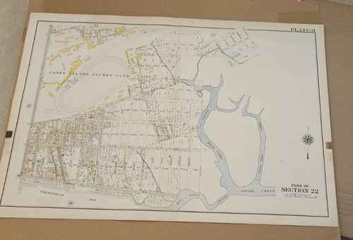
Two 1899/1907 Hand-Colored New York City NYC Maps, Morris Park, Coney Island
The other shows Morris Park and the surrounding area in the Bronx.

1962 Map Book and Farm Directory Allamakee County, Iowa, Ads! Rare
Great old 1962 Map Book and Farm Directory for Allamakee County, Iowa, Many Ads! Softcover. 48 pages. Measures 9 1/4" x 12 1/2". Very scarce. Book is in very good condition. Intact. Pages are primarily clean & bright; minor soiling on lower margin edge of about half of pages. Small bend on upper corners. Covers display moderate soiling & tanning. Minor corner wear. Smoke-free home.
You save $65.99

HARDINSBURG, BRECKENRIDGE COUNTY, KENTUCKY Antique authentic geology map 1901
Antique original Julius Bien lithograph map published in "The TWENTY-SECOND ANNUAL REPORT OF THE U.S. GEOLOGICAL SURVEY, 1900-1901". Titled, Plate XXVII. "PART OF BRECKENRIDGE COUNTY, KENTUCKY". Very good + condition.

1911 INYO National Forest Map California Nevada Mt Diablo US Dept of Agriculture

1904 Holophane Glass Co St. Louis World Fair Folding Map Louisiana Purchase Expo
The lower margin is printed “Holophane Glass Exhibit, Space 25, Electricity Building”. This map is an original antique issued in 1904.

1905 Latest Map Of The Connecticut Valley In Massachusetts, Geo. H. Walker, RARE
Wonderful antique "Latest Map Of The Connecticut Valley In Massachusetts", Published By Geo. H. Walker & Co. Lithographers, Boston, Mass. 1905. No other copies are listed on the Internet.
You save $231.00

Rare 1890 Folding Guide Map of New York City
Issued folded in half vertically with six horizontal folds.
You save $173.75
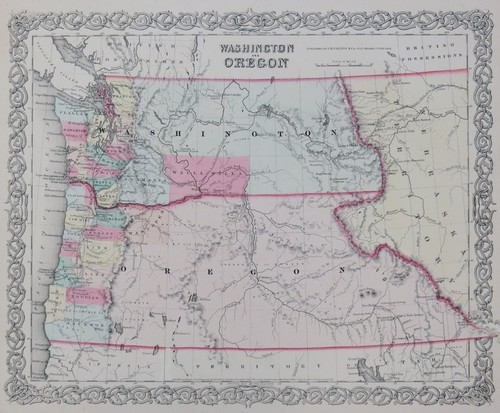
ORIGINAL 1853 COLTON'S HAND COLORED MAP OF WASHINGTON & OREGON TERRITORY
Publisher: J. H. Colton & Co. Date: 1853. Antique hand colored map is toned but clean and in very good condition. 18.5" x 16".

"WEST VIRGINIA" Antique original state map 1907
Note mark top border, mat will hide. Antique original map by C.S. Hammond & Co. Shows, "WEST VIRGINIA". Excellent condition. Published in Encyclopedia Britannica, 1907. This map is an original antique NOT a reproduction.

CINCINNATI antique town city plan. Ohio. BAEDEKER 1909 old map chart
Antique colour map. Scale 1:36.500, 1909. DATE PRINTED: 1909. TITLE OF THE MAP: 'Cincinnati'. 'Cincinnati'. TYPE: Antique colour map. Scale 1:36.500. CONDITION: Good; suitable for framing.

1927 Antique WESTERN UNITED STATES Original Map T.B. Johnston Chambers W. Coast
1927 Western United States Antique Map W. & R. Chambers T.B. Johnston. This detailed plate focuses on the Western United States, capturing the vast geography stretching from the Pacific Coast to the Great Plains.

Antique Map 6 Fold Out Postcards Map Chicago Map New House #s 1908 Issues In Pic
The product is an antique postcard featuring a fold out with 6 designs of various parks in Chicago, including Humboldt Park, Jackson Park, and Garfield Park. The postcard also includes a map of new house numbers in the city. The postcard is themed around touring bus routes and provides a detailed look at different locations within the city. It is a unique and collectible piece for anyone interested in topographical postcards and the history of Chicago's parks.

ORIGINAL 1855 COLTON'S HAND COLORED MAP OF ILLINOIS
Publisher: J. H. Colton & Co. Date: 1855. Antique hand colored map is toned but clean and in very good condition. 18.5" x 16".

1863 Asher & Co. Broadside 'The Historical War Map' - U.S. Civil War
The accessible overview provided by the map made it hugely popular, and it was issued in a range of different versions. Ours is the later and most extensive state, which includes a complete list of every single military confrontation; from the initiation of hostilities at Fort Sumter in April of 1861 up to a skirmish between four Union gunboats and a group of rebels at St Charles, Arkansas, on June 17th of 1862.

Two Antique California Gold Rush Monterey German Engravings Hermann Meyer 1850
Monterey 4 1/2" x 6 1/2", paper size 6 1/2" x 8 7/8".

1988 City Graphics Pictorial Map View Potrero Hill, San Francisco , California
A whimsical pictorial view of the Potrero Hill, Dogpatch, and Mission Bay neighborhoods of San Francisco, produced in 1988 by City Graphics. The view is oriented towards the north, with San Francisco Bay at right and the U.S.-101 highway at left.

Civil War Map Position Yorktown w/ Approaches, Secession Works Yorktown 1862
Picture 2 shows the number of sections of the plate, what that section depicts and under whose authority it was produced. This is the original plate XV (15) from the Atlas Book 3, Part III from 1891 making this plate over 130 years old.

ORIGINAL 1855 COLTON'S HAND COLORED MAP OF CALIFORNIA
Publisher: J. H. Colton & Co. Date: 1855. Antique hand colored map is toned but clean and in very good condition. 18.5" x 16".

Antique 1884 Map of Long Island showing the Long Island Railroad & Connections

Washington DC. Pictorial city map by Ruth Taylor White 1935 old vintage
DATE PRINTED: 1935. CONDITION: Good; suitable for framing. CAPTION BELOW PICTURE: 'Washington, District of Columbia, The National Capital'.

Bedrock Geologic Map of Massachusetts—E-an Zen—U.S. Geological Survey 1983
Bedrock Geologic Map of Massachusetts [Sheet 1 of 3]. CAPTION BELOW PICTURE: 'Bedrock Geologic Map of Massachusetts [Sheet 1 of 3]'. DATE PRINTED: 1983.

Civil War Framed Hand Colored 1865 Map Of Chattanooga & Defenses Charles Sholl
Engineers". Shows the extensive rebel fortifications around the city colored in red.

Goldfield Merger Mine Company Mining District Map Esmeralda County Nevada 55x32

1853 U.S. COASTAL SURVEY MAP 'SEPARATE ISSUE' SAN FRANCISCO TO SAN DIEGO
"U.S. COAST SURVEY.RECONNAISSANCE OF THE WESTERN COAST OF THE UNITED STATES - LOWER SHEET - SAN FRANCISCO TO SAN DIEGO". Collectors seek out examples of this 'separate' issue as the preferred example over the regular issue which is frequently plagued with fold lines, fold separations, heavy foxing, tears, and other distracting flaws.
You save $297.00

c. 1849 Currier and Ives Lithograph, California Gold Rush Prosepctor
This is Nathaniel Currier’s celebrated lithograph iconic artwork portraying a gold prospector traveling to California during the Gold Rush. The most iconic California Gold Rush lithograph.