South America Maps
south america maps — pre-owned
Browse 39 south america maps — pre-owned on eBay — listings updated every few minutes. All items are pre-owned and sold by eBay sellers directly.

Santa Fe and its first Colonies. Argentina 1885 old antique map plan chart
'Santa Fé and its first Colonies'. TITLE OF MAP: 'Santa Fé and its first Colonies'. Antique wood-engraved map. Scale 1:250,000, 1885. DATE PRINTED: 1885. CONDITION: Good; suitable for framing. VERSO: There are images and/or text printed on the reverse side of the picture.
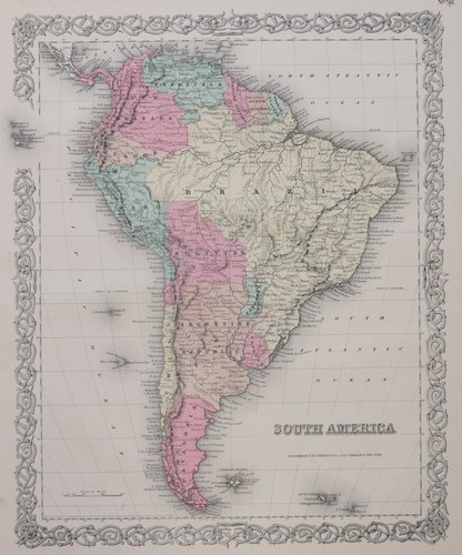
ORIGINAL 1855 COLTON'S HAND COLORED MAP OF SOUTH AMERICA
Publisher: J. H. Colton & Co. Date: 1855. Antique hand colored map is toned but clean and in very good condition. 18.5" x 16".

Latin America: Economic & Linguistic - 1941 Vintage WW2 Serial Map Service Map
A very attractive map, originally extracted from an original Serial Map Service Subscription publication. see photo.
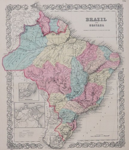
ORIGINAL 1855 COLTON'S HAND COLORED MAP OF BRAZIL AND GUAYANA
Publisher: J. H. Colton & Co. Date: 1855. Antique hand colored map is toned but clean and in very good condition. 18.5" x 16".

Frontiers of Venezuela 1885 old antique vintage map plan chart
'Frontiers of Venezuela'. TITLE OF MAP: 'Frontiers of Venezuela'. Antique wood-engraved map. Scale 1:18,000,000, 1885. DATE PRINTED: 1885. PROVENANCE: "The Universal Geography"; by Élisée Reclus, Edited by A.H. Keane, Published by J.S. Virtue & Co., London /Venezuela/ [Universal Geography].

BRITISH GUIANA (GUYANA). Vintage map. Guyana. Caribbean 1935 old vintage
'British Guiana'. TITLE OF MAP: 'British Guiana'. DATE PRINTED: 1935. CONDITION: Good; suitable for framing. The map you will receive is in good condition but there may be minor variations in the condition from that shown in the image.

Tunguraghua and Pastaza Gorge. Ecuador 1885 old antique vintage map plan chart
'Tunguragua and Pastaza Gorge'. TITLE OF MAP: 'Tunguragua and Pastaza Gorge'. Antique wood-engraved map. Scale 1:900,000, 1885. DATE PRINTED: 1885. PROVENANCE: "The Universal Geography"; by Élisée Reclus, Edited by A.H. Keane, Published by J.S. Virtue & Co., London /Ecuador/ [Universal Geography].
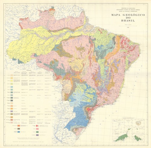
Mapa Geológico do Brasil—Alberto Ribeiro Lamego—Ministério da Agricultura 1960
PROVENANCE: Ministério da Agricultura, Brasil. Impresso no Serviço Gráfico do IBGE. 'Mapa Geológico do Brasil'. CAPTION BELOW PICTURE: 'Mapa Geológico do Brasil'. DATE PRINTED: 1960. DEUTSCHLAND: Alte Lankarten und Stadt ansichten.

La Guaira. Venezuela 1885 old antique vintage map plan chart
'La Guaira'. TITLE OF MAP: 'La Guaira '. Antique wood-engraved map. Scale 1:25,000, 1885. DATE PRINTED: 1885. PROVENANCE: "The Universal Geography"; by Élisée Reclus, Edited by A.H. Keane, Published by J.S. Virtue & Co., London /Venezuela/ [Universal Geography].

Cultivated Zone, Dutch Guyana. Suriname. Gold mines. Forests 1885 map
Antique wood-engraved map. Scale 1:4,000,000, 1885. DATE PRINTED: 1885. VERSO: There are images and/or text printed on the reverse side of the picture. TYPE: Antique wood-engraved map. Scale 1:4,000,000.

1910- PAN AMERICAN-SOUTH AMERICA- RAILWAY- ROUTE MAP-RAILROAD RIVER-OCEAN-33"
BY RAILWAY- RIVER & OCEAN.

BRITISH GUIANA (GUYANA) . Vintage map. Guyana. Caribbean 1914 old antique
'British Guiana'. TITLE OF MAP: 'British Guiana'. DATE PRINTED: 1914. CONDITION: Good; suitable for framing. VERSO: There is nothing printed on the reverse side, which is plain.

'Carte de la Province de Quito au Perou'. Western Ecuador. BELLIN 1756 old map
Par Mr. d'Anville de l'Acad. Imperiale de Petersburg 1751 [Map of the province of Quito in Peru]. Imperiale de Petersburg 1751 [Map of the province of Quito in Peru]'. Antique copperplate map, 1756. DATE PRINTED: 1756.

ORIGINAL 1855 COLTON'S HAND COLORED MAP OF CENTRAL AMERICA
Publisher: J. H. Colton & Co. Date: 1855. Antique hand colored map is toned but clean and in very good condition. 18.5" x 16".
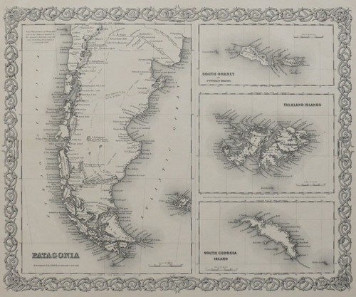
ORIGINAL 1855 COLTON'S MAP OF PATAGONIA, SOUTH ORKNEY, FALKLAND ISLANDS, SOUTH
Publisher: J. H. Colton & Co. Date: 1855. Antique map is toned but clean and in very good condition. 18.5" x 16".
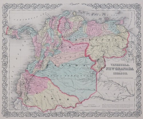
ORIGINAL 1855 COLTON'S HAND COLORED MAP OF VENZUELA, NEW GRANADA AND ECUADOR
Publisher: J. H. Colton & Co. Date: 1855. Antique hand colored map is toned but clean and in very good condition. 18.5" x 16".

West Coast of South America. Chile, Bolivia & Peru. FULLARTON c1863 old map
Large hand coloured antique atlas map, c1863. PROVENANCE: "The Royal Illustrated Atlas of Modern Geography", with an introductory notice by Dr. N. Shaw., Secretary to the Royal Geographical Society. CONDITION: Fair: Tide mark across top left hand corner and along bottom edge.

Carácas and la Guaira. Venezuela 1885 old antique vintage map plan chart
'Carácas and la Guaira'. TITLE OF MAP: 'Carácas and la Guaira'. Antique colour map, 1885. DATE PRINTED: 1885. PROVENANCE: "The Universal Geography"; by Élisée Reclus, Edited by A.H. Keane, Published by J.S. Virtue & Co., London /Venezuela/ [Universal Geography].

Indigenous populations of Ecuador 1885 old antique vintage map plan chart
'Indigenous populations of Ecuador'. TITLE OF MAP: 'Indigenous populations of Ecuador'. Antique wood-engraved map. Scale 1:10,000,000, 1885. DATE PRINTED: 1885. PROVENANCE: "The Universal Geography"; by Élisée Reclus, Edited by A.H. Keane, Published by J.S. Virtue & Co., London /Ecuador/ [Universal Geography].

Sierra Nevada de Merida. Venezuela 1885 old antique vintage map plan chart
Antique wood-engraved map. Scale 1:600,000, 1885. DATE PRINTED: 1885. PROVENANCE: "The Universal Geography"; by Élisée Reclus, Edited by A.H. Keane, Published by J.S. Virtue & Co., London /Venezuela/ [Universal Geography].

Vitoria/Vitória, Espirito Santo. Brazil 1885 old antique map plan chart
Antique wood-engraved map. Scale 1:140,000, 1885. DATE PRINTED: 1885. CONDITION: Good; suitable for framing. VERSO: There are images and/or text printed on the reverse side of the picture. TYPE: Antique wood-engraved map.

"Carte du Perou, avec une partie des pays a l'Est". Peru Ecuador. BONNE 1780 map
Notation on rear says 1743 but we believe this is the 1780 printing.

1904 South America Map – Dodd Mead – Original Antique Color Lithograph
Published: New York, 1904. Technique: Original color lithograph. This is an original 1904 antique map — not a reproduction. Style: Early 20th-Century Color Lithographed Continental Map. Plate: Single-sheet encyclopedia map.

BRITISH GUIANA (GUYANA). Vintage map. Guyana. Caribbean 1931 old vintage
'British Guiana'. TITLE OF MAP: 'British Guiana'. DATE PRINTED: 1931. CONDITION: Good; suitable for framing. The map you will receive is in good condition but there may be minor variations in the condition from that shown in the image.

Valparaiso Bay — Coast of Chile by the Officers of HMS Beagle. Darwin 1842 map
A chart of Valparaíso “by the officers of H.M.S. Beagle,” dated 1835. Engraved by John and Charles Walker. Antique engraved map, 1842. DATE PRINTED: 1842.

Brazil. South America East Coast. Bahia. Rio de Janeiro. SWANSTON 1860 old map
Antique atlas map with original hand colour, 1860. DATE PRINTED: 1860. CONDITION: Good; suitable for framing.

Double chain of Ecuadorean Volcanoes 1885 old antique vintage map plan chart
'Double chain of Ecuadorean Volcanoes'. TITLE OF MAP: 'Double chain of Ecuadorean Volcanoes'. Antique wood-engraved map. Scale 1:4,500,000, 1885. DATE PRINTED: 1885. CONDITION: Good; suitable for framing.

GEORGETOWN. Vintage town map. British Guiana (Guyana) /Guyana. Caribbean 1931
'Georgetown, British Guiana'. TITLE OF MAP: 'Georgetown, British Guiana'. DATE PRINTED: 1931. CONDITION: Good; suitable for framing. The map you will receive is in good condition but there may be minor variations in the condition from that shown in the image.

ORIGINAL 1855 COLTON'S HAND COLORED MAP OF PERU AND BOLIVIA
Publisher: J. H. Colton & Co. Date: 1855. Antique hand colored map is toned but clean and in very good condition. 18.5" x 16".

ORIGINAL 1855 COLTON'S HAND COLORED MAP OF ARGENTINE REPUBLIC, CHILI, URUGUAY &
Publisher: J. H. Colton & Co. Date: 1855. Antique hand colored map is toned but clean and in very good condition. 18.5" x 16".

CHILE showing Puna de Atacama as Chilean. Patagonia JOHNSTON 1892 old map
Antique colour map, 1892. DATE PRINTED: 1892. PROVENANCE: "The World-Wide Atlas of Modern Geography"; By J. Scott Keltie; published by W. & A.K. Johnston, London: 1st Edition [World wide atlas]. 'Chile; Chile (Northern Portion); Chile (Southern Portion)'.

Marañon and Ucayali confluence. Pacaya-Samiria. Requena. Nauta. Peru 1885 map
'Marañon and Ucayali confluence'. TITLE OF MAP: 'Marañon and Ucayali confluence'. Antique wood-engraved map. Scale 1:1,600,000, 1885. DATE PRINTED: 1885. PROVENANCE: "The Universal Geography"; by Élisée Reclus, Edited by A.H. Keane, Published by J.S. Virtue & Co., London /Peru/ [Universal Geography].

Mapa Geológico de la República Oriental del Uruguay—Geological—Arocena 1946
'Mapa Geológico de la República Oriental del Uruguay'. CAPTION BELOW PICTURE: 'Mapa Geológico de la República Oriental del Uruguay'. PROVENANCE: Instituto Geológico del Uruguay, Montevideo. Impreso en los talleres graficos de la Imprenta Nacional, Montevideo.

Dutch West Indies & South America. Curaçao Guyana Surinam St. Martin c1863 map
Large hand coloured antique atlas map, c1863. Colonised Portion of Dutch Guyana'. TYPE: Large hand coloured antique atlas map. AUTHENTICITY: This is an authentic historic print, published at the date stated above.

VENEZUELA - SOUTH AMERICA Antique original map 1936
Single map, image of reverse. Very good + condition. Published in New York by P.F. Collier & Son Corporation, 1936. This is NOT a reproduction.

Ancient highways of the Incas. Peru 1885 old antique vintage map plan chart
'Ancient highways of the Incas'. TITLE OF MAP: 'Ancient highways of the Incas'. Antique wood-engraved map. Scale 1:17,000,000, 1885. DATE PRINTED: 1885. PROVENANCE: "The Universal Geography"; by Élisée Reclus, Edited by A.H. Keane, Published by J.S. Virtue & Co., London /Peru/ [Universal Geography].

CHILE. Regions provinces steamship routes. Valparaiso Concepcion plans 1920 map
'Chile; Inset Valparaiso; Concepcion'. CAPTION BELOW PICTURE: 'Chile; Inset Valparaiso; Concepcion '. DATE PRINTED: 1920. CONDITION: Good; suitable for framing. The map you will receive is in good condition but there may be minor variations in the condition from that shown in the image.

"CHILI, LA PLATA OR ARGENTINE REPUBLIC & BOLIVIA" Antique South America map 1889
Sturdy paper. Antique original map titled, "CHILI, LA PLATA OR THE ARGENTINE REPUBLIC &BOLIVIA".

South America: Economic - 1941 Vintage WW2 Serial Map Service Map
A very attractive map, originally extracted from an original Serial Map Service Subscription publication. see photo. Two binding holes to one edge. Light horizontal crease towards bottom of map.