World Maps
world maps — pre-owned
Browse 975 world maps — pre-owned on eBay — listings updated every few minutes. All items are pre-owned and sold by eBay sellers directly.

Vintage Republic of South Africa Tour Planning Map
An excellent historical reference for mid-century African travel. Peace of Mind We want you to love your find. Republic of South Africa Tour Planning Map highlighting Johannesburg. Part of the charm of our curiosities is their history.

1945 Czech Fabric Handkerchief Embroidered On Silk Original
The product is a 1945 Czech fabric handkerchief embroidered on silk the country in which it was made, which is an original piece from the period. This unique handkerchief serves as a collectible item and is thematically tied to militaria, making it a valuable addition for history enthusiasts and collectors interested in original period items from the Civil War era. as the translation reads: The nation of Czechoslovakia sacrificed all its historical achievements in 1938 in order to spoil world peace, which neither a thousand years nor wars could change! Czechoslovakia regained its freedom in 1945 with the help of the great allies, famously the Red, American and British armies! long live the nations of the ussr, usa and great britain! - true knight!- this is a used item, please see pictures.
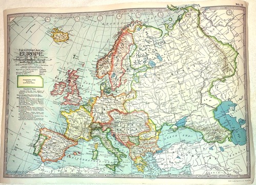
Map - Europe 1914 - Century Atlas World - Vintage Poster Art Reproduction - 26..
Author: Century Atlas. Notes: Map reproduction, 2005. Qty Available: 16. Sku: sku1211224.

3D Wooden Map Of North America W/Pin Holes For Marking Visited States.Pre Owned.
This product is a 3D wooden map of North America with pinholes. It serves as a unique and decorative collectible item, perfect for displaying pins or other small items. The detailed design and craftsmanship of the map make it a standout piece for any pin collector or enthusiast of North American geography. As shown in photos : USA, Mexico, Canada, Alaska, Greenland, Hawaii, Puerto Rico with pin holes on every state which is convenient to mark as visited state. Used item. Backside has some wall attachment reminiscent from previous wall.

BRITISH EMPIRE. World Mercator. Currents. Steamship routes. JOHNSTON 1910 map
PROVENANCE: "The World Wide Atlas of Modern Geography Political and Physical"; by J. Scott Keltie; Published by W. & A. K. Johnston, Edinburgh & London. 7th Edition (revised) [World wide atlas]. Colour antique map, 1910.

Antique 1903 Rand-McNally Universal Atlas Of The World 14” x 11.5”
Antique 1903 Rand-McNally Universal Atlas Of The World Nice antique shape. Shows some wear and age. See pictures to make your own determination on physical condition. Measures 14x11.5", Thank you

"North Atlantic Ocean" showing Nelson's & trade routes. THOMSON 1817 old map
Antique early 19th century atlas map with original hand colouring, 1817. DATE PRINTED: Published in 1817.

Azores. Saõ Miguel. Terceira. Fayal. Pico. Saõ Jorge. SAMLER BROWN 1932 map
'Azores or Western Islands // Saõ Miguel // Terceira // Fayal // Pico // Saõ Jorge'. CAPTION BELOW PICTURE: 'Azores or Western Islands // Saõ Miguel // Terceira // Fayal // Pico // Saõ Jorge'. PROVENANCE: "Brown's Madeira, Canary Islands and Azores", by A. Samler Brown.

1899 Spanish American War Lithograph Map of Hawaiian Islands - FRAME FOR GIFT
CURRIER & IVES AND KURZ & ALLISON CIVIL WAR PRINTS.CURRIER & IVES CIVIL WAR PRINTS. + MUCH MORE. A NICE 127 YEAR OLD MAP. WONDERFUL FOR FRAMING --- GIFT OR ADD TO YOUR COLLECTION, MAN CAVE.

Bottle Chart of the Atlantic Ocean by A. B. Becher. Oceanic currents 1852 map
A striking and scientifically important thematic chart, Alexander Bridport Becher’s Bottle Chart of the Atlantic Ocean (1852) represents one of the earliest systematic attempts to map ocean circulation.

ISLANDS. Malta Madeira Bermuda Reunion Hawaii Tahiti Mauritius. WELLER 1862 map
(Reunion); Mauritius; Sandwich Isles or Hawaiian Archipelago; Viti or Fiji Islands'. Antique map with original outline colour, 1862. DATE PRINTED: 1862. TYPE: Antique map with original outline colour.
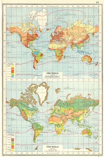
WORLD. Showing Rainfall & Vegetation. Jan & July temperatures 1920 old map
DATE PRINTED: 1920. AUTHENTICITY: This is an authentic historic print, published at the date stated above. It is not a modern copy. CONDITION: Good; suitable for framing.

Vintage Sunoco Massachusetts Connecticut Rhode Island Map
Condition: Good, vibrant colors, standard fold creasing. Peace of Mind We want you to love your find. Part of the charm of our curiosities is their history. The Black Series by shift3 5-Piece Wine Accessory Set.

Vintage BP Oil Northeastern U.S. Interstate Map
Peace of Mind We want you to love your find. Original BP Oil Northeastern U.S. Interstate Map. Part of the charm of our curiosities is their history. The Black Series by shift3 5-Piece Wine Accessory Set.
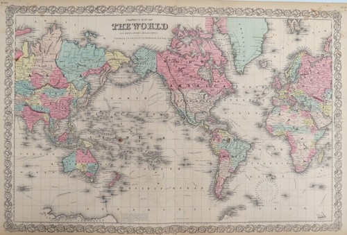
ORIGINAL 1855 COLTON'S HAND COLORED MAP OF THE WORLD
Publisher: J. H. Colton & Co. Date: 1855. Antique hand colored map is toned but clean and in very good condition. 32" x 18.5".

Ghostly Mysteries Triple Pack.
This bundle is perfect for fans of the supernatural and those who love a good mystery.

Bouvet Island sketches from Norris's 1825 Sprightly log. Admiralty/RGS 1928 map
A set of coastal profiles and a small chart of Bouvet Island, one of the most remote and inhospitable places on earth, copied from Admiralty records of the 19th-century sketches made by Captain George Norris aboard the sealer Sprightly.

Brick City: LEGO® for Grown Ups by Elsmore, Warren Book The Fast Free Shipping
Author:Elsmore, Warren. In fact, landmarks and cityscapes - from the New York skyline to the Sagrada Familia, London's St Pancras and the amazing towers of Beijing and Hong Kong - have long been a source of inspiration for LEGO builders.
You save $9.03

Blood, Toil, Tears & Sweat—Empire Supply Routes—Richard Edes Harrison 1940 map
Colour printed folding map/diagram of “Twenty Strategic Essentials” and imperial “Miles from the Front”, drawn by Richard Edes Harrison for Fortune in May 1940. DATE PRINTED: Dated May 1940. Published July 1940.

Vintage Ephemera National Geographic February 1963 Map Antarctica Unopened map
Unopened, map as was a magazine insert. magazine is not included. excellent Unopened condition. 1963 February Has not been opened from original plastic sleeve. carefully packaged, fast shipping.

ARCTIC. Terres Arctiques. Continent Arctique. North Pole. MALLET 1683 old map
'Continent Arctique' (Terres Arctiques). TITLE OF THE MAP: 'Continent Arctique'. Original 17th century copperplate map, 1683. DATE PRINTED: 1683. CONDITION: Good; suitable for framing. The map you will receive is in good condition but there may be minor variations in the condition from that shown in the image.

Vintage 1950s Hammond’s International Map of the World

Atlantic Ocean showing depths & telegraph cables. THE TIMES 1895 old map
Antique colour atlas map, 1895. DATE PRINTED: 1895. 'Atlantic Ocean'. CAPTION BELOW PICTURE: 'Atlantic Ocean '. CONDITION: Good; suitable for framing. AUTHENTICITY: This is an authentic historic print, published at the date stated above.

AMERICAS SHOWING CALIFORNIA AS AN ISLAND. 'Nouveau Continent'. MALLET 1683 map
Original 17th century copperplate map, 1683. DATE PRINTED: 1683. 'Nouveau Continent avec plusieurs Isles' (Du Globe Terrestre). TITLE OF THE MAP: 'Nouveau Continent avec plusieurs Isles'. VERSO: There is nothing printed on the reverse side, which is plain.

WORLD. Vegetation. Ocean Currents. Food crops. Agricultural commodities 1944 map
DATE PRINTED: 1944. This map was printed in an atlas that was published during the Second World War. AUTHENTICITY: This is an authentic historic print, published at the date stated above. It is not a modern copy.

Atlantic Arena—Persuasive map—World War 2—Richard Edes Harrison—Fortune 1944
PROVENANCE: "Look at the World—A Fortune Atlas for World Strategy", by Richard Edes Harrison, text by the editors of Fortune. New York: Alfred A. Knopf. Atlantic Arena. This 1944 atlas-edition reissue of Harrison’s map, first published in 1942, presents the Atlantic not as empty ocean but as the industrial and logistical heart of Allied war power.

Diversi globi terr-aquei statione variante… World Planisphere. Seutter c1744 map
Antique 18th century copperplate map with original wash colour, c1744. Planisphaerium coeleste. Diversi globi terr-aquei statione variante et visu intercedente, per coluros tropicoriorum. Per ambos polos et particul.

The Azores with inset town plan of Horta, Faial — The Nautical Magazine 1842 map
'The Azores'. CAPTION BELOW PICTURE: 'The Azores'. Antique engraved map, 1842. DATE PRINTED: 1842. AUTHENTICITY: This is an authentic historic print, published at the date stated above. It is not a modern copy.

Players - Navy Cut medium - Tobacco Tin
Players - Navy Cut medium - Tobacco Tin. Condition is Used. Dispatched with Royal Mail 2nd Class.

Very Rare Players Navy Cut Cigarettes 50 tin vintage
Awesome

Players Medium Navy Cut 50gTobacco Tin Box.
Players Medium Navy Cut 50gTobacco Tin Box.. Condition is Used. Dispatched with Royal Mail 2nd Class.

Players - Navy Cut medium - Tobacco Tin
Players - Navy Cut medium - Tobacco Tin. Condition is Used. Dispatched with Royal Mail 2nd Class.

NORTH ATLANTIC OCEAN. inset Panama Canal;Gran Canaria;Madeira. Cables 1920 map
DATE PRINTED: 1920. CONDITION: Good; suitable for framing. This map was originally printed as two separate pages which have been professionally joined to form a single sheet. AUTHENTICITY: This is an authentic historic print, published at the date stated above.

Coronelli Globe Gore. Azores & Cape Verde Islands/North Atlantic Ocean 1695 map
Coronelli's globe gores are uncommon. PROVENANCE: Vincenzo Maria Coronelli, Venice. [Untitled Globe Gore - Azores and Cape Verde Islands / Central North Atlantic Ocean]. CAPTION BELOW PICTURE: '[Untitled Globe Gore - Azores and Cape Verde Islands / Central North Atlantic Ocean]'.

1898 Burlington Cedar Rapids Northern Railway Spanish American War Atlas Antique
The Burlington, Cedar Rapids & Northern Railway operated from 1875 to 1903. Overall condition is very good for this antique original. Burlington, Cedar Rapids & Northern Ry. WAR ATLAS With Marginal Index.

FRENCH COLONIES & TRADING POSTS 1683. Colonies et comptoirs Français 1931 map
'Colonies et comptoirs Français en 1683. TITLE OF MAP: 'Colonies et comptoirs Français en 1683. PROVENANCE: "Atlas Colonial Français. Édité par l'Illustration. DATE PRINTED: 1931. DEUTSCHLAND: Alte Lankarten und Stadt ansichten.

NORTH ATLANTIC OCEAN. Telegraph cables/dates. Ocean currents/velocities 1886 map
Antique colour map, 1886. DATE PRINTED: 1886. 'The North Atlantic Ocean, on the Gnomonic Projection'. CAPTION BELOW PICTURE: 'The North Atlantic Ocean, on the Gnomonic Projection'. TYPE: Antique colour map.

Chart drawn by the natives by Captain John Ross—2nd Arctic Expedition 1835 map
In the context of the expedition, the chart also undercuts the usual heroic narrative of solitary discovery, showing that survival and mapping in the Arctic were collaborative processes, even when later presented through British naval authority.
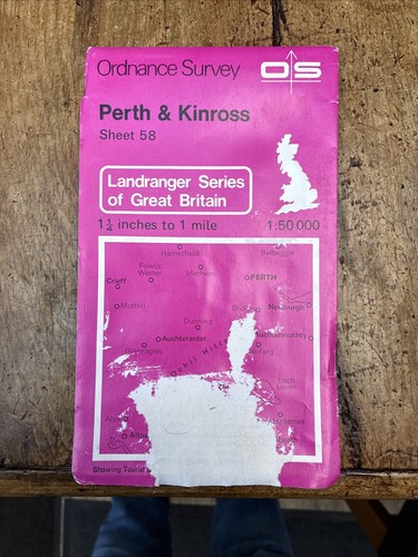
Dolgellau and Surrounding Area: Sheet 58 Landranger Maps) - Ordnance Survey
Dolgellau and Surrounding Area: Sheet 58 Landranger Maps) - Ordnance Survey

Collectable Vintage Players Whisky Brown Flake Tobacco Tin , FREE UK POSTAGE .
Awesome