Maritime Navigational Charts
maritime navigational charts — pre-owned
Browse 2,351 maritime navigational charts — pre-owned on eBay — listings updated every few minutes. All items are pre-owned and sold by eBay sellers directly.

Admiralty 1106 MAZATLAN MEXICO - WEST COAST MARITIME NAUTICAL GENIUS Map Chart
WHY CHOOSE MARINE FEDERATION. No worries! The photographs shown are of the actual item. Our dedicated team is always available to assist you with any queries or concerns regarding your order.
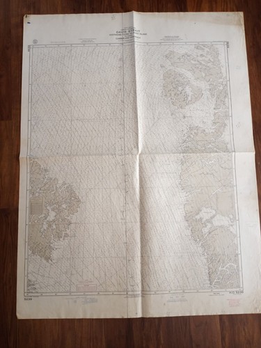
ORIGINAL ANTIQUE MAP TERRITORY NAUTICAL CHART Davis Strait Disko Island Canada
Godthaabs FJord to Disko Island. Cumberland Peninsula is a peninsula in the southeastern part of Baffin Island in Nunavut, Canada. It is located between 64°56' and 67°57' north latitude, and 61°56' to 68° west longitude.

ORIGINAL ANTIQUE MAP TERRITORY NAUTICAL CHART Egedesminde Torssukatak Disko Bugt
Egedesminde to Torssukatak including Disko Bugt. [8] report fighting and massacres on both sides. Disko Bay ( Greenlandic : Qeqertarsuup tunua ; Danish : Diskobugten. Disko Bay has been an important location for centuries. ).
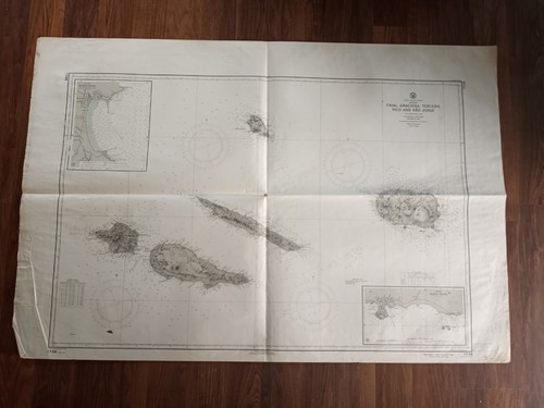
ORIGINAL ANTIQUE MAP TERRITORY NAUTICAL CHART Azores Faial Graciosa Terceira
Azores Faial Graciosa, Terceira Pico and Sao Jorge. The Triangle : Faial in the foreground, Pico in thebackground and to the right, and to the left, stretching between the sea andthe sky. São Jorge.

Admiralty 1307 MEXICO EAST COAST BAHIA DE CAMPECHE Map Chart Maritime Nautical
WHY CHOOSE MARINE FEDERATION. No worries! The photographs shown are of the actual item. Our dedicated team is always available to assist you with any queries or concerns regarding your order.

13 X 16 In. Framed New Haven Channel Nautical Map
13 X 16 In. Framed New Haven Channel Nautical Map. Condition is Used. Shipped with USPS Ground Advantage.

Admiralty 2229 SOUTH AMERICA BRAZIL RIO AMAZONAS ALMEIRIM TO MANAUS Chart Map
Our dedicated team is always available to assist you with any queries or concerns regarding your order. Visual Accuracy. The photographs shown are of the actual item. WHY CHOOSE MARINE FEDERATION.

Admiralty 3171 SOUTHERN APPROACHES TO THE STRAIT OF HORMUZ Map Chart Maritime
Looking for more marine or industrial products?. Visual Accuracy: What you see is what you get. No worries!
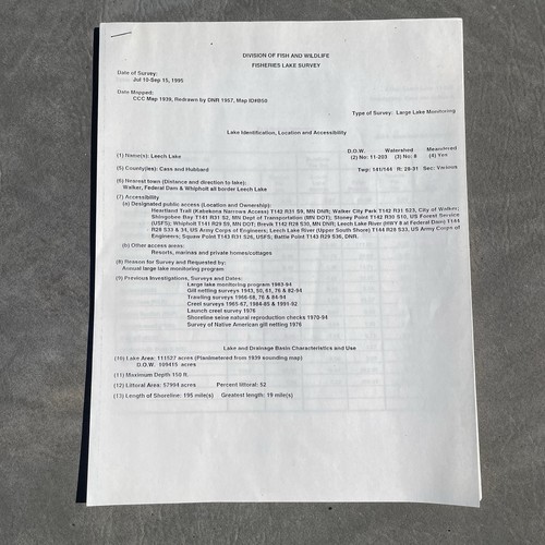
1995 Leech Lake MN Lake Survey And 1994 Leech Lake Map
This is a Division of Fish & Wildlife Fisheries 1995 Leech Lake Survey. Lake Identification, Location & Accessibility Report. With a 1994 Leech Lake, MN lake map. Please see photos for more info on contents and condition.
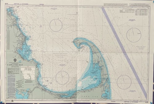
Admiralty 3096 CAPE COD BAY UNITED STATES - EAST COAST MASSACHUSETTS Map Chart
No worries! Countries Served. Our dedicated team is always available to assist you with any queries or concerns regarding your order.

VTG 1985 NOAA Gulf Of Mexico Nautical Marine History Data Atlas Map Plates Large
The binder itself has bends and soiling and the rings don't fully close. The pages (plates) have soiling. I tried to include photos of the WORST plates and defects. There are a total of 94 plates (most are double sided).

Admiralty 608 Africa West Coast The Gambia River Gambia Entrance Chart Map Wall
What you see is exactly what you get. The photographs shown are of the actual item. No worries! Our dedicated team is always available to assist you with any queries or concerns regarding your order.

Admiralty 2391 Part Of Guimaras Strait Chart Map Maritime Marine Wall Nautical
WHY CHOOSE MARINE FEDERATION. What you see is exactly what you get. The photographs shown are of the actual item. No worries! Worldwide Orders. Our dedicated team is always available to assist you with any queries or concerns regarding your order.
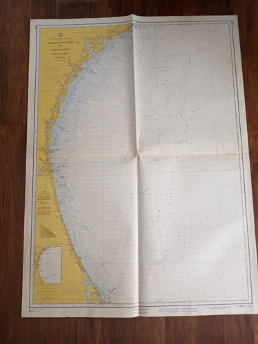
ORIGINAL ANTIQUE MAP NAUTICAL CHART Charleston Light to Cape Kennedy Hilton Head
[3] It is 20 miles (32 km) northeast of Savannah, Georgia, and 95 miles (153 km) southwest of Charleston. Charleston Light, also known as Sullivan's Island Lighthouse, is located on Sullivan's Island, South Carolina, which is the northern entrance to Charleston Harbor.

ORIGINAL ANTIQUE MAP NAUTICAL CHART Asia Viet Nam Batangan Ile Buffle China Sea
Cap Batangan to Ile Buffle (Hon Trau). Asia South China Sea Viet Nam. ANTIQUE ORIGINAL MAP TERRITORY NAUTICAL CHART. [Thismap is not a reproduction or from a scan, and it's printed on a thick papermatting surface. ].

ORIGINAL ANTIQUE MAP NAUTICAL CHART Baffin Bay canada greenland Lancaster Sound
The narrower Nares Strait connects Baffin Bay with the Arctic Ocean. However, a polynya of about 80,000 km. [pronunciation? ]. lies off the northern end of Baffin Island in Nunavut Territory, Canada.

Admiralty 2755 APPROACHES TO NEW YORK HARBOR Maritime Genius Nautical Map Chart
WHY CHOOSE MARINE FEDERATION. 100% Original. Our dedicated team is always available to assist you with any queries or concerns regarding your order. Visual Accuracy. The photographs shown are of the actual item.
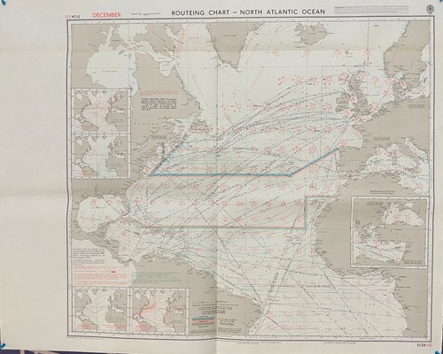
Admiralty 5124(12) ROUTEING CHART NORTH ATLANTIC OCEAN NAUTICAL MARINE Map Chart
WHY CHOOSE MARINE FEDERATION. 100% Original. The photographs shown are of the actual item. Our dedicated team is always available to assist you with any queries or concerns regarding your order.

Admiralty 593 West Indies Approaches To Guadeloupe Map Chart Maritime Marine Wal
WHY CHOOSE MARINE FEDERATION. Our dedicated team is always available to assist you with any queries or concerns regarding your order. Visual Accuracy. The photographs shown are of the actual item.
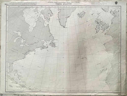
Admiralty 5095 NORTH ATLANTIC Maritime Nautical Genius Marine Wall Map Chart
WHY CHOOSE MARINE FEDERATION. The photographs shown are of the actual item. Our dedicated team is always available to assist you with any queries or concerns regarding your order.

Admiralty 2426 Pulau Redang To Hon Khoai Gulf Of Thailand Vintage Map Ship Chart
The photographs shown are of the actual item. What you see is exactly what you get. Our dedicated team is always available to assist you with any queries or concerns regarding your order. Visual Accuracy.

Admiralty 1160 HARBOURS IN SOMERSET NORTH DEVON ENGLAND - BRISTOL CHANNEL Map
What you see is exactly what you get. No worries! Our dedicated team is always available to assist you with any queries or concerns regarding your order.
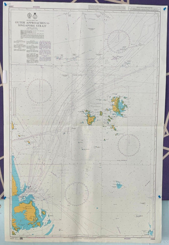
Admiralty 2869 SOUTH CHINA SEA OUTER APPROACHES TO SINGAPORE STRAIT Map Chart
Our dedicated team is always available to assist you with any queries or concerns regarding your order. Visual Accuracy. The photographs shown are of the actual item. WHY CHOOSE MARINE FEDERATION.
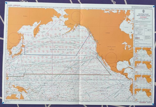
Admiralty NOVEMBER 5127 ( 11 ) ROUTEING CHART NORTH PACIFIC OCEAN Map Chart Wall
100% Original. No worries! Our dedicated team is always available to assist you with any queries or concerns regarding your order.

Admiralty 2490 UNITED STATES MAINE MONHEGAN ISLAND TO CAPE PORPOISE Map Chart
Our dedicated team is always available to assist you with any queries or concerns regarding your order. Visual Accuracy. The photographs shown are of the actual item. WHY CHOOSE MARINE FEDERATION.

Admiralty 5095 NORTH ATLANTIC Maritime Nautical Genius Marine Map Chart Wall
WHY CHOOSE MARINE FEDERATION. The photographs shown are of the actual item. Our dedicated team is always available to assist you with any queries or concerns regarding your order.

Admiralty 4617 PACIFIC OCEAN TUVALU TO PALMYRA ISLAND Map Chart Maritime Genius
WHY CHOOSE MARINE FEDERATION. Our dedicated team is always available to assist you with any queries or concerns regarding your order. Visual Accuracy. The photographs shown are of the actual item.
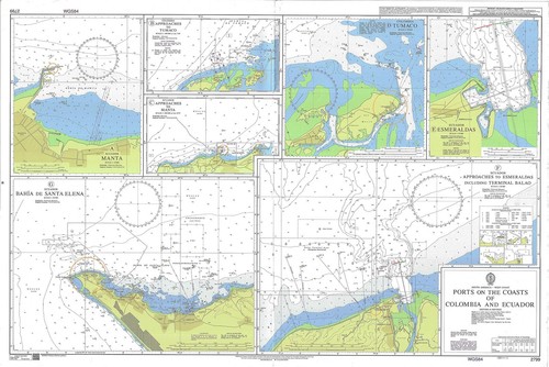
Admiralty 2799 Ports On The Coasts Of Colombia And Ecuador Chart Map Marine Wall
WHY CHOOSE MARINE FEDERATION. What you see is exactly what you get. The photographs shown are of the actual item. No worries! Worldwide Orders. 100% Original. Our dedicated team is always available to assist you with any queries or concerns regarding your order.

Roll Top Nautical Chart Organizer Navigation Cabinet
An interesting wooden roll top desk organizer, presumably for nautical use or use on a train. Its previous use was as an organizer for art supplies mounted vertically on the wall. In well used condition and comes with various marks and scratches, nothing bad or overtly noticbcable. Otherwise good condition. Please refer to photos for more information and DM with any questions!

ORIGINAL ANTIQUE MAP TERRITORY NAUTICAL CHART Georges Bank and Nantucket Shoals
Georges Bank and Nantucket Shoals. By the 1850s, it was known simply as Georges Bank.

ORIGINAL ANTIQUE MAP TERRITORY Red Sea Gulf of Suez NAUTICAL CHART 1871
(Along the mid-line of the gulf is the boundary between Africa and Asia. "Sea of Calm") is a gulf at the northern end of the Red Sea, to the west of the Sinai Peninsula. Situated to the east of the Sinai Peninsula is the smaller Gulf of Aqaba.

Nautical Chart Ellender, LA To Galveston Bay, TX Gulf Map 1981 Wall Size 58x15
Shows Gulf intracoastal waterway from Ellender, LA to Galveston Bay, TX. Nautical Chart no. 11331. Year:1981 ; double-sided color laminated wall map.

Admiralty 1510 North Pacific Ocean US Hawaiian Islands Hawaii To Nihoa Chart Map
Our dedicated team is always available to assist you with any queries or concerns regarding your order. Visual Accuracy. The photographs shown are of the actual item. WHY CHOOSE MARINE FEDERATION.

Admiralty 1379 APPROACHES TO KUANTAN PENINSULAR MALAYSIA - EAST COAST Map Chart
Our dedicated team is always available to assist you with any queries or concerns regarding your order. No worries! Visual Accuracy. The photographs shown are of the actual item. WHY CHOOSE MARINE FEDERATION.

Admiralty 8004 PORT APPROACH GUIDE LONG BEACH AND LOS ANGELES Map Chart Maritime
WHY CHOOSE MARINE FEDERATION. What you see is exactly what you get. 100% Original. No worries! Our dedicated team is always available to assist you with any queries or concerns regarding your order.
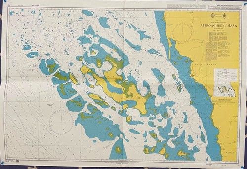
Admiralty 15 APPROACHES TO JIZAN RED SEA SAUDIARABIA AND YEMEN Genius Map Chart
100% Original. Our dedicated team is always available to assist you with any queries or concerns regarding your order. Visual Accuracy. The photographs shown are of the actual item. WHY CHOOSE MARINE FEDERATION.

Admiralty 3857 SOUTHERN APPROACHES TO THE MISSISSIPPI RIVER MARITIME Map Chart
WHY CHOOSE MARINE FEDERATION. What you see is exactly what you get. The photographs shown are of the actual item. Our dedicated team is always available to assist you with any queries or concerns regarding your order.
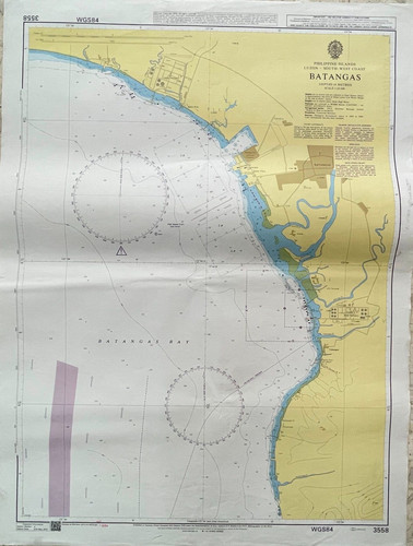
Admiralty 3558 BATANGAS PHILIPPINE ISLANDS Genius Nautical Paper Wall Map Chart
WHY CHOOSE MARINE FEDERATION. The photographs shown are of the actual item. Our dedicated team is always available to assist you with any queries or concerns regarding your order.

Admiralty 4980 US Alaska-South Coast Prince William Sound Eastern Entrance Map
QUALITY / SERVICE / AUTHENTICITY. No worries! Visual Accuracy. The photographs shown are of the actual item. 100% Original. Our dedicated team is always available to assist you with any queries or concerns regarding your order.
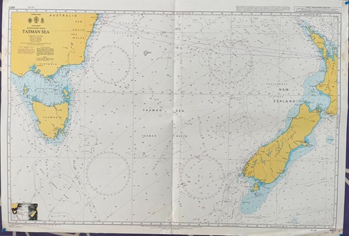
Admiralty 4601 TASMAN SEA SOUTH PACIFIC OCEAN NAUTICAL GENIUS PAPER Map Chart
WHY CHOOSE MARINE FEDERATION. The photographs shown are of the actual item. Our dedicated team is always available to assist you with any queries or concerns regarding your order.