Maps
maps — pre-owned
Browse 6,184 maps — pre-owned on eBay — listings updated every few minutes. All items are pre-owned and sold by eBay sellers directly.

Penn Central RR PCRR Track Chart Williamsport Division January 1 1972
Item is dated 1-1-1972. Item is very long and thick. Item is in very good condition and displays little usage.

1915 Map Of The Pacific Northwest Oregon Washington Idaho Union Pacific System
c1915 Map of the Pacific Northwest issued by the Union Pacific System. Size: 22” x 24” unfolded. Condition: VG Overall. Light cover wear, a couple of small crease splits, one larger one (shown in pics). No marks, no writing, no stains. Original.

Eastern Counties Omnibus Co Ltd. 1931. LNER; LMS lines/Map. ORIGINAL
LNER; LMS lines/Map. ORIGINAL (not a copy). Eastern Counties Omnibus Co Ltd. 1931.

1922 Antique Maine Central Railroad System Map Vintage Railway Map 3122
It is dated 1922 on the bottom right corner. This is an antique map which was carefully removed from a financial book. It is in very good condition - note creasing on the bottom border and.

Lot of 3 EURAIL Brochures and Maps, 1976, 1978, 1982
Lot of 3 EURAIL brochures/maps, from 1976, 1978, and 1982. All in excellent condition!

1905 Map BOSTON NORTHERN & OLD COLONY STREET RAILWAY COMPANY Massachusetts
This is not a reprint.

1914 Antique Map of INDIANA Railroads Map ORIGINAL Atlas Map CCC & St L Ry DATED
This is a RARE Original atlas map of Indiana dated 1914, which was taken from a 1915 atlas.
You save $7.49

MILWAUKEE ROAD SUBURBAN SERVICE MAP - 10/1979
Milwaukee Road. Tickets by Mail for commuting on the Milwaukee Road, opens to nice map of their suburban routes. Still shows service to Walworth, Wisconsin, Rondout, Illinois and Hermosa stations. October 1979. Four panel folder. 4" x 9". Map measures 8" x 9". Shipping via USPS First Class Mail. I will also consolidate orders, if requested, to save on shipping costs.
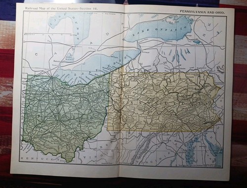
~1895 Antique Railroad Map PENNSYLVANIA & OHIO all Train Line Companies Marked
This is not a reprint. Shows stations, Depots, and connections. 130 years old paper must be handled with care. These are loose pages removed from a larger book. I did the best I could to remove them with care from.

1911 Florida Railroad Map ORIGINAL Atlas Florida East Coast Railway DATED
This is an Original atlas map of Florida dated 1911, which was taken from a 1911 atlas.
You save $7.49
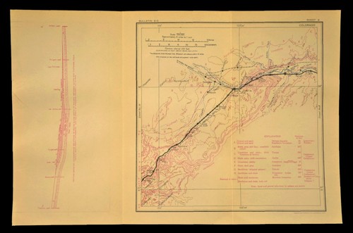
1915 Antique Santa Fe Railroad Map La Junta Colorado Las Animas CO Geological
This is an original 1915 trifold geological map on a type of vellum with two vertical folds. This map shows the Santa Fe line from Thatcher Colorado to Hilton Colorado. Unique to this map is that it has a chart of the Geology with matching letters on the map image.
You save $3.74

Vintage Southern Pacific RR Map Terrell County Texas Dryden Pumpville Ghost Town
This is an original circa 1930 trifold geological map on a type of vellum with two vertical folds. This map shows the line from Longfellow Texas to Pumpville Texas. Unique to this map is that it has a chart of the Geology with matching letters on the map image.
You save $2.99
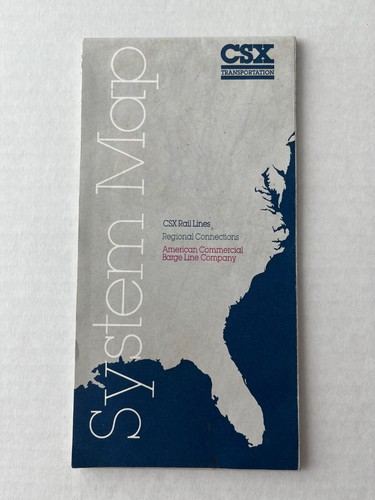
Two CSX foldable system maps.
Two foldable CSX system maps. One map has a copy right date of 1989. The other map has no date on it. CSX was formed in 1980 so I would estimate the map is early 1980's. Both maps are in good condition but the older map has a little more wear and tear on it. the older map does have some small tears as represented in one of the pictures. The older map is very colorful as you can tell from the pictures.

Original 1878 Map of the Railroads of the State of Massachusetts. Big Map
Original 1878 Map of the Railroads of the State of Massachusetts. Big Map. Good condition for its age. The paper has marks, scuffs, foxing. Expected wear of a almost 150 year old map. Sold as is with no returns so please look at the photos and ask questions before bidding. Shipping is $16.60. Thank you for your time

1912 International Congress Applied Chemistry Colorado Photos and Railroad Map
Vintage 1912 souvenir portfolio from the Eighth International Congress of Applied Chemistry tour, featuring the Denver & Rio Grande Railroad and Pennsylvania Railroad. This historical ephemera set includes a large fold-out map of the United States detailing the Pacific Coast and Chicago-Boston tour routes, along with a sepia-toned photograph of a steam locomotive traversing the Canon of the Grand River in the Colorado Rockies. The photograph is signed by Geo. L. Beam and includes an original business card for Frank A. Wadleigh, General Passenger Agent, clipped to the top. The outer envelope features decorative gold-tone seals and "See America" branding, serving as a rare piece of early 20th-century railroad and scientific history.
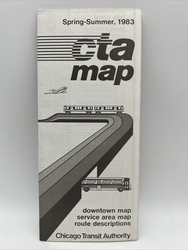
1983 Spring-Summer CHICAGO TRANSIT AUTHORITY CTA ROUTE MAP Train L Subway Bus
You save $51.99

1897 Train Route Map + Report CHICAGO ROCK ISLAND & PACIFIC RAILWAY Indian Ter.
This is not a reprint.

1922 Antique Denver Rio Grande Railroad Map Montrose Colorado Delta CO Gunnison
This is an original 1922 geological map on a type of vellum with two vertical folds. Unique to this map is that it has a chart of the Geology with matching letters on the map image.
You save $4.19
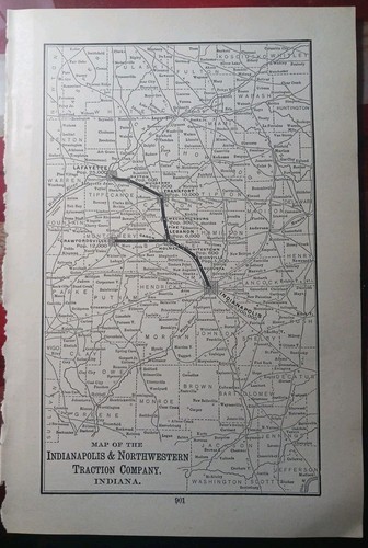
~1904 RARE Railroad Map INDIANAPOLIS & NORTHWESTERN TRACTION CO Trolley Routes
Goes to Indianapolis. and Crawfordsville Indiana with lots of other towns in between. This is not a reprint.

1888 Antique Railroad Map CALIFORNIA & NEVADA ALL Train Route lines Depots 11x9"
Beautiful crisp color with lots of detail. This is not a reprint.
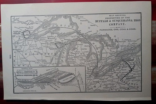
~1904 RARE Railroad Map BUFFALO & SUSQUEHANNA IRON COMPANY Ore Coal Coke Furnace
This is not a reprint.

Buffalo Rochester & Pittsburgh Railway - Original 1917 Map by Poor's Publishing

Railroad Distance Map of Pennsylvania Jan 26, 1906 Large 40" x 27" Erie, PA
This was found in an old court house book.
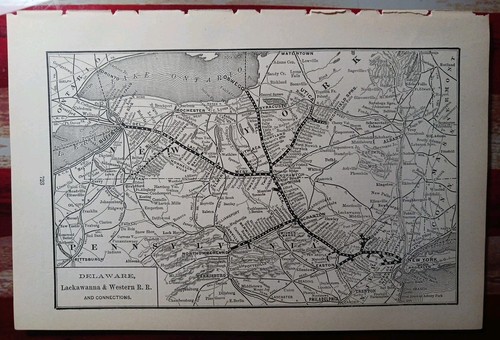
1892 Antique Railway Map DELAWARE LACKAWANNA & WESTERN RAILROAD Train Routes
This is NOT a reprint. These are loose pages removed from a larger book. I did the best I could to remove them with care. in very good condition for age.
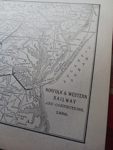
1906 dated Train Route Map NORFOLK & WESTERN RAILWAY And Connections All Lines
This is not a reprint.
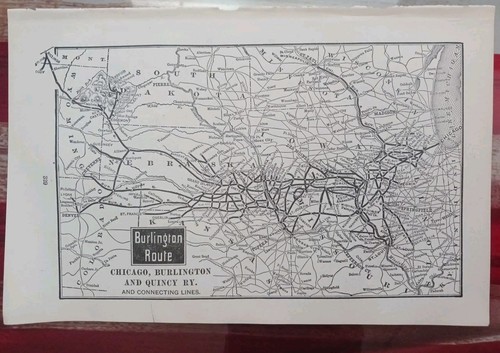
1905 RAILROAD Map BURLINGTON ROUTE Chicago Burlington & QUINCY Railway All Lines
All Lines marked. This is not a reprint.
1892 Antique Railroad Map SOUTHER PACIFIC COMPANY all Train Line Routes CA NM AZ
This is NOT a reprint. These are loose pages removed from a larger book. I did the best I could to remove them with care. in very good condition for age.
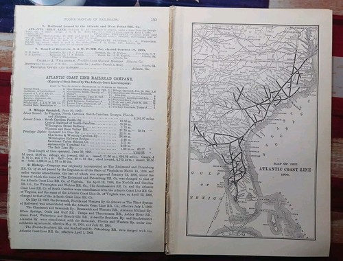
1906 Train Route Map + Report ATLANTIC COAST LINE RAILROAD Florida Georgia VA NC
This is not a reprint.

1916 Antique United Railways of Havana Regla Map Cuba Railroad Map 3099
And REGLA WAREHOUSES MAP. ANTIQUE UNITED RAILWAYS OF THE HAVANA. It is dated 1916 below the title, top left corner. The map is in very good condition - note it has four original folds.

1934 Antique Pennsylvania Railroad Map Vintage Pennsylvania Railway Map 2551
It is dated 1934 on the bottom left edge. This is an antique map which was carefully removed from a 1940 book on finance. and age toning on the top edge.

1920 Antique Louisville & Nashville Railroad Map L & N Railroad Map 2946

RARE 1940’s Railroad Map & Engineer/Fireman Senority List 1896-1942
Many blessings.

~1895 Train Route Map PENNSYLVANIA RAILROAD All Lines East Of Pittsburgh Marked
Original 1895, page just under 6" by 9", in good condition for age. This is not a reprint. Map is 6x9 in, one page. Shows stations, Depots, and connections.

~1895 Train Route Map PENNSYLVANIA RAILROAD All Lines West Of Pittsburgh Marked
Original 1895, page just under 6" by 9", in good condition for age. This is not a reprint. Map is 6x9 in, one page. Shows stations, Depots, and connections.

1925 INDIANA HARBOR BELT RAILROAD Map ORIGINAL Chicago - Gary - Indiana Harbor
The product is an original 1925 map of the Indiana Harbor Belt Railroad published by Poole Brothers and measuring 17x10.5 inch.es entire sheet. Very detailed antique map showing the routes of the Indiana Harbor Belt railroad with state lines, connecting routes, townships and waterways. Map is a valuable piece of history for collectors interested in North American maps and railroads from the early 20th century. Good condition, creases as issued

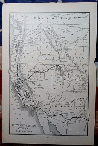
1904 Railroad Map SOUTHERN PACIFIC SYSTEM west All Lines Stations CA NV AZ WA OR
This is not a reprint.

Vintage Illinois Terminal Railroad System Map Illinois Traction System ca 1932
This map includes a legend under the title which identifies the various lines on the map indicating freight and passenger steam and electric lines, as well as lines under construction and inter-change connections.
You save $4.49

1892 Antique Railroad Map BURLINGTON ROUTE Chicago Burlington & Quincy All Lines
This is NOT a reprint. These are loose pages removed from a larger book. I did the best I could to remove them with care. in very good condition for age.
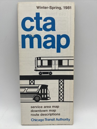
1981 Winter-Spring CHICAGO TRANSIT AUTHORITY CTA ROUTE MAP Train L Subway Bus
You save $51.99

1924 Antique Reading Railway Map Vintage Reading Lines Railroad Map 3124
ANTIQUE READING RAILWAY MAP. It is dated 1924 on the bottom right corner.