Maps & Atlases
maps & atlases — pre-owned
Browse 127 maps & atlases — pre-owned on eBay — listings updated every few minutes. All items are pre-owned and sold by eBay sellers directly.
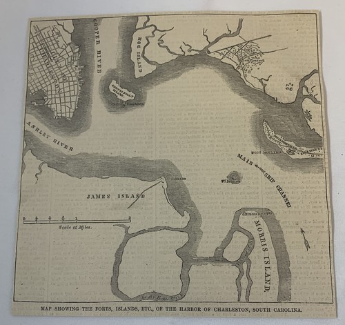
1861 newspaper map ~ HARBOR OF CHARLESTON, SOUTH CAROLINA
Not a photocopy or more recent reproduction.

Original 1859 Civil War Map Great Currents and Drifts of the Ocean 13 x 23” FL1
You save $37.50
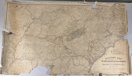
1865 Civil War Military Map Sherman’s March American Lithographic Co
• The surviving “Lithographic Co.” text. Under Command of Maj. Gen. W. T. Sherman, U.S.A.”. • Sherman’s March to the Sea. Covering the years 1863, 1864, 1865. Published 1865. • Compiled by order of: Maj. Gen. W. T. Sherman, U.S.A.

Framed 1863 Civil War Chickamauga Campaign Map Newspaper New York Herald Georgia
1863 original Civil War newspaper featuring a large engraved battlefield campaign map titled 1863 period newspaper. • Civil War collectors. “Important Operations in Georgia”. • Historical map collectors.
1865 Civil War Map Battle of Chattanooga Lookout Mountain Missionary Ridge TN
An Authentic Antique Map: Not a Modern Reproduction! Condition: It is in Very Good to Excellent condition for its age, blank on reverse. The pics are of the actual map.
You save $4.00
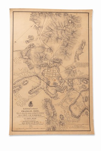
1874 Franklin TN Civil War Map 19x28.5 Original American Litho Co
Fresh to market and previously undisplayed. This is an original period lithograph, not a reproduction.

Atlas for official records of the Union and Confederate Armies 1861-1865 18"x29"

Johnson's New Chart of National Emblems, 1863-w/Rare National Flag
Johnson's New Chart of National Emblems, 1863. This version of the flag was the one that draped the coffin of Stonewall Jackson, killed May 10, 1863. -w/"Stainless" Version of the Confederate Flag.

Civil War Battlefields Sites Complete Sinclair 1961 Rand McNally Centennial Map
This is a Civil War Battlefields Sites Complete Sinclair 1961 Rand McNally Centennial Map. There are some stains, pen mark and corner fold. Please see photos for condition details. This map comes from a smoke free home. Thank you for looking!
You save $7.79

Original Civil War Map Plate LXV – Petersburg, Dutch Gap James R., Texas Coast
Coast of Texas and its defenses. Great Detail! ten insets. Sketch no. Size: 30" x 18" (76 cm x 46 cm).
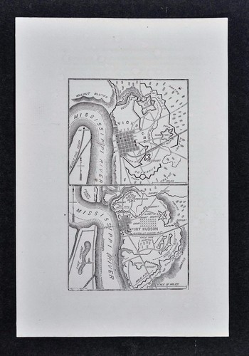
1865 Civil War Map - Mississippi River Campaign Vicksburg Baton Rouge New Orlean
An Authentic Antique Map: Not a Modern Reproduction! Condition: It is in Very Good condition for its age, blank on reverse. The pics are of the actual map.
You save $4.00
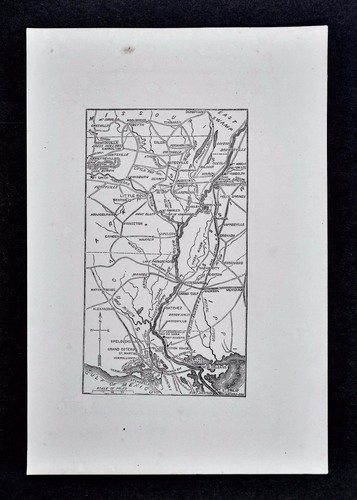
1865 Civil War Map Richmond Petersburg Five Forks Dinwiddie Appomattox Virginia
Condition: It is in Good to Very Good condition for its age, blank on reverse. The pics are of the actual map. An Authentic Antique Map: Not a Modern Reproduction!
You save $4.00

Civil War Map Plate LX – Atlanta Campaign 4th & 5th Epochs – Sherman vs. Hood
(Covers the period after crossing the Chattahoochee River to the siege lines outside Atlanta. Union and Confederate positions during mid-July 1864.). Great Detail!
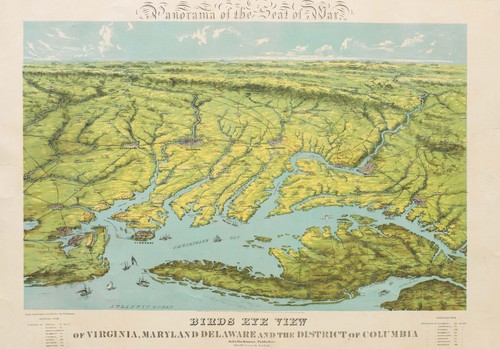
1861 Bachmann Panorama of the Seat of the War (First State), U.S. Civil War
The mapmaker's perspective allows a wide geographical window and a remarkable amount of detail. This remarkable view, published by John Bachmann amid the Civil War, constitutes a sweeping panorama of a critical theater of the war, where the northern Confederacy and southernmost part of the Union collide.
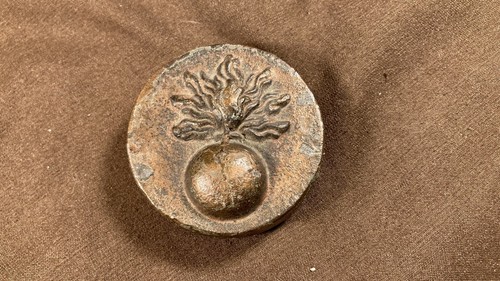
Antique Civil War Map Weight, Paperweight Rare
Antique Civil War Map Weight, Paperweight. Check out my other items! pd2

Antique Atlas Civil War Lithograph CXXII Fort Sumter Moultrie 1863 Beauregard CS
Offering a fine group of original 1893 folio maps from the "Atlas to Accompany the Official Records of the Union and Confederate Armies", a comprehensive record of detail during the four years of the Civil War. 29-1/2" x 18-1/2". These are in overall very good antique condition. Never openly sold, being distributed only to Federal depositories & other institutions. Original, single fold as issued. FEATURING here an original 1893 lithograph plate CXXII featuring 11 assorted images of the South Caroline Forts Sumter and Moultrie in April, 1861. Remarkable detail, most have a subtitle explaining the image, and accompanied the reports of Brig General G.T. Beauregard, C.S. Army.

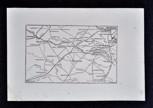
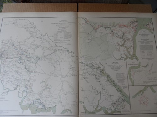
Civil War Map Plate LXVI – Westport, Five Forks VA , Johnson’s Island prison OH
📌 Plate LXVI – Map Insets (Campaigns & Battlefields). Map of the Battle of Westport and Big Blue River, Missouri. Detailed Battle Map – Westport and Big Blue, October 1864. Johnson’s Island Military Prison was a Union facility located on a small island in Lake Erie, near Sandusky, Ohio.
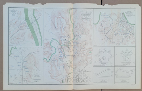
Civil War Map Plate CXII Fort Rosecrans, Nashville Defenses, Alabama Rail Hubs
📌Plate CXII – Civil War Forts and Rail Centers in Tennessee & Alabama. Topographic Sketch of Fortress Rosecrans (center map). Defenses of Nashville, Tennessee. Map of Bridgeport, Alabama. Map of Stevenson, Alabama.

MILITARY MARCHES MAP MAJ GEN WT SHERMAN US FORCES COMMAND 1863 - 1865 CIVIL WAR
Detail: Military Map showing the marches of the United States Forces under command of Maj. Genl. W.T. Sherman. U.S.A. during the years 1863, 1864, 1865. Map Subject: Civil War - Military Marches under command of W. T. Sherman.

Civil War Map Plate CXI – VA Battles, Chattanooga, Knoxville, Tenn. Forts
– Shows forts and redoubts established after the Union’s victory in late 1863. Diagram – Defenses of Chattanooga, Tennessee. Diagram – Defenses of Knoxville, Tennessee. Map of the Battle of Cross Keys, VA (June 8, 1862).

1862 Civil War newsaper with a MAP of CAPE HATTERAS North Carolina PAMLICO SOUND
New York Herald datedJan 29, 1862. This original newspaper contains a prominent 5" x 5" front page map headlined: "THE BURNSIDE EXPEDITION / Map Showing Hatteras Inlet, Cape Hatteras, and Loggerhead Inlet.".

1890s Civil War Map of Lacey Spring, VA. By Jedediah Hotchkiss, Plate # 84.
Authentic 1890s antique lithograph map in good overall condition. The central map image is bright and crisp.

1876 Map of the Battle of Iuka, Mississippi, showing positions of U Civil War
1876 Map of the battle of Iuka, Mississippi, showing the positions of the U.

Atlas to accompany the official records of the union & confederate armies CXXIX
Atlas to accompany the official records of the union & confederate armies CXXIX. Some tears, etc. See photos. Will ship flat as folded naturally in the last photo.

Mobile Bay Naval Battle Vintage Civil War History Graphic Illustration Print
THE GREAT NAVAL. TERRIFIC COMBAT RESULTING IN THE CAPTURE OF RAM. AND ONE OF THE GUNBOATS, THE OTHERS RUN ASHORE OF DESTROYED. CURRIER & IVES REPRODUCTION.

1862 Civil War newspaper w detailed MAP of RICHMOND Virginia CONFEDERATE CAPITOL
1862 Civil War newspaper with a detailed front page MAP of RICHMOND Virginia as the CONFEDERATE CAPITOL - inv # 4T-338. NY World dated Oct 14, 1862. This original newspaper contains a prominent 9" x 5" front page detailedMAP of the Confederate capitol of RICHMOND, Virginia.

Antique Map Civil War 1862 Penninsula Campaign fascinating maps! plate XXI
Skirmish at New Bridge, VA June 5, 1862 Malvern Hill. Battle of New Marker, VA June 30, 1862 Hanover Court-House, VA May 27, 1862. Size: 30" x 18" (76 cm x 46 cm).

Civil War 80 Ton Gun Gunnery Turret Antique Engineering Graphic Lithograph Print
CANNON TURRET. CIVIL WAR ERA. 80 TON GUNS. ANTIQUE GRAPHIC ART. WEAPONS ENGINEERING.

1862 Bache / Coast Survey 'Map of Eastern Virginia' U.S. Civil War
The map was issued at the height of the Civil War and provided a full overview of Eastern Virginia and the Delaware Peninsula. Particular focus was on the the ‘capitals' of Washington D.C. and Richmond and their hinterlands.

Civil War Map Position Yorktown w/ Approaches, Secession Works Yorktown 1862
Picture 2 shows the number of sections of the plate, what that section depicts and under whose authority it was produced. This is the original plate XV (15) from the Atlas Book 3, Part III from 1891 making this plate over 130 years old.

Antique Atlas 1861 Civil War Plate CXXIII 35 Image Artillery Cavalry Guns Sword
Offering a fine group of original 1893 folio maps from the "Atlas to Accompany the Official Records of the Union and Confederate Armies", a comprehensive record of detail during the four years of the Civil War. 29-1/2" x 18-1/2". These are in overall very good antique condition. Never openly sold, being distributed only to Federal depositories & other institutions. Original, single fold as issued. FEATURING here an original 1893 lithograph plate CXXII featuring 11 assorted images of the South Caroline Forts Sumter and Moultrie in April, 1861. Remarkable detail, most have a subtitle explaining the image, and accompanied the reports of Brig General G.T. Beauregard, C.S. Army.
Civil War Map Army Of Potomac Williamsburg To White House To Harrisons Landing
Picture 2 shows the number of sections of the plate, what that section depicts and under whose authority it was produced. The Atlas was not released to the general public but rather to museums, universities and public institutions.
![[MAP] Johnson's Florida](https://i.ebayimg.com/images/g/x~cAAeSwwsJqKwmB/s-l500.jpg)
[MAP] Johnson's Florida
All are suitable for framing and valued by collectors. New York: Johnson & Browning, 1860.

Original 1862 Civil War Map RICHMOND Petersburg Norfolk Petersburg York Virginia
Original full-page woodblock engraved map of Richmond and vicinity shortly after the start of Peninsula Campaign during the Civil War, in the spring of 1862. The map was published in the May 17, 1862 edition ofHarper's Weekly and is in very good condition,bright and clean, withno marks or writing.
![[MAP] Johnson's Illinois (c. 1860)](https://i.ebayimg.com/images/g/le8AAeSw9XlqKwoC/s-l500.jpg)
[MAP] Johnson's Illinois (c. 1860)
All are suitable for framing and valued by collectors. [MAP] Johnson's Illinois. New York: Johnson & Browning, ca. 1860.

Original 1862 Civil War Map RICHMOND Virginia Malvern Hill James River Canal
Original full-page woodblock engraved map of the country surrounding Richmond, drawn after the Battle of Malvern Hill. On the reverse side there are two panoramic views drawn by Alfred R. Waud: "Heron Creek, Near Harrison's Landing, on Which the Right Wing of the Army Rests" and "Kimmidge's Creek, Left Defense of the Camp at Harrison's Landing.".
![[MAP] Johnson's Nebraska and Kansas Territories (c. 1860)](https://i.ebayimg.com/images/g/~7QAAeSwiRFqKwlc/s-l500.jpg)
[MAP] Johnson's Nebraska and Kansas Territories (c. 1860)
All are suitable for framing and valued by collectors. This undated map is version 2.0 in Ira Lourie's Johnson U.S. Map Project and was printed only in the years 1860 and 1861. Hand-colored in pink and yellow.

Civil War Hand-Drawn Map of Central Tennessee Between Cumberland & Duck Rivers
During the Civil War, the Cumberland and Duck Rivers played significant roles in the Western Theater. The Confederates established a fortified line along the Duck River to counter the Union Army of the Cumberland.
Antique Atlas Map Civil War Folio ORIG 1865 Iron Clad Ships Rebel Lines Military
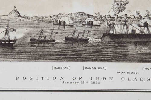
Offering a fine group of original 1893 folio maps from the "Atlas to Accompany the Official Records of the Union and Confederate Armies", a comprehensive record of detail during the four years of the Civil War. 29-1/2" x 18-1/2". These are in overall very good antique condition. Never openly sold, being distributed only to Federal depositories & other institutions. Original, single fold as issued. FEATURING here an original 1893 lithograph plate CXXIX featuring 10 assorted images relating to the Rebel Lines around Atlanta Georgia. Most accompanied the report of Capt. Poe, Corps of Engrs, U.S. Army. Striking image from January 15th, 1865 depicting the positions of the Iron Clad Ships. GREAT reference tool.

Vintage Large 2-Sided Battlefields Of The Civil War Map 23x30 Poster.
Vintage Large 2-Sided Battlefields Of The Civil War Map 23x30 Poster.