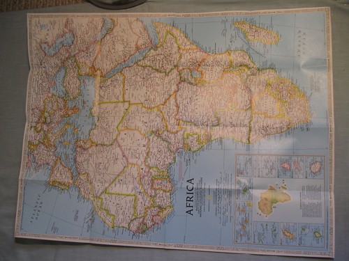
Africa
africa — pre-owned
Browse 197 africa — pre-owned on eBay — listings updated every few minutes. All items are pre-owned and sold by eBay sellers directly.

ANCIENT EGYPT WALL MAP + THE EGYPTIANS National Geographic April 2001
Ancient Egypt Wall Map + The Egyptians Great Peoples of the Past April 2001 This two-sided poster is in excellent condition with no marks or tears. It is an original map that was in a National Geographic magazine. It is 20" x 31". 1021.

VINTAGE AFRICA COUNTRIES OF THE NILE MAP National Geographic October 1963
Africa Countries of the Nile Map October 1963 This poster is in mint condition. It is an original map that was in a National Geographic magazine. It is 19" x 25". 416 Terms: Powered by The free listing tool. List your items fast and easy and manage your active items. Powered by The free listing tool. List your items fast and easy and manage your active items. Powered by The free listing tool. List your items fast and easy and manage your active items. Powered by The free listing tool. List your items fast and easy and manage your active items.

VINTAGE AFRICA MAP+ POLITICAL DEVELOPMENT National Geographic February 1980
Africa Map + It's Political Development February 1980 This two-sided poster is in mint condition. It is an original map that was in a National Geographic magazine. It is 22" x 3". 316 Terms: Powered by The free listing tool. List your items fast and easy and manage your active items. Powered by The free listing tool. List your items fast and easy and manage your active items. Powered by The free listing tool. List your items fast and easy and manage your active items. Powered by The free listing tool. List your items fast and easy and manage your active items.

National Geographic Map Nile Valley Land of the Pharaohs Egypt 1965 Africa
The National Geographic Map of the Nile Valley and the Land of the Pharaohs from 1965 offers a detailed exploration of the ancient civilization and geography of Egypt. This collectible map provides a unique glimpse into the transportation and infrastructure of Africa during that time period, showcasing the majesty of the Nile River and the significant historical sites along its banks. Ideal for history buffs, cartography enthusiasts, and collectors of vintage maps, this piece of cartographic art captures a moment in time and place in the vast and intricate history of Africa.

VINTAGE LARGE AFRICA & THE ARABIAN PENINSULA MAP National Geographic March 1950
Africa and The Arabian Peninsula Map March 1950 Includes physical map of Africa This large one-sided poster is in very good condition with no marks or tears. It is an original map that was in a National Geographic magazine. It is 29" x 31". 920.

VINTAGE AFRICA MAP National Geographic September 1960
Africa Map September 1960 This one-sided poster is in very good condition with no marks or tears. Some folds have been taped for reinforcement. It is an original map that was in a National Geographic magazine. It is 19" x 25". 226.

EGYPT'S NILE VALLEY THE NORTH & THE SOUTH MAP National Geographic January 1995
Egypt's Nile Valley Map The North and The South Historical Site Information January 1995 This two-sided poster is in mint condition. It is an original map that was in a National Geographic magazine. It is 10" x 32". 116 Terms: Powered by The free listing tool. List your items fast and easy and manage your active items. Powered by The free listing tool. List your items fast and easy and manage your active items. Powered by The free listing tool. List your items fast and easy and manage your active items. Powered by The free listing tool.

THE GREAT RIFT VALLEY+ AFRICA'S LAKES MAP National Geographic November 2011
Africa's Great Lakes Map + The Great Rift Valley November 2011 This two-sided poster is in mint condition with no marks or tears. It is 20" x 31". 418.

VINTAGE SOUTHERN AFRICA MAP National Geographic November 1962
Southern Africa Map November 1962 This poster is in mint condition. It is an original map that was in a National Geographic magazine. It is 19" x 25". 416 Terms: Powered by The free listing tool. List your items fast and easy and manage your active items. Powered by The free listing tool. List your items fast and easy and manage your active items. Powered by The free listing tool. List your items fast and easy and manage your active items. Powered by The free listing tool. List your items fast and easy and manage your active items.

1922 Map COLONIAL AFRICA Mandates Railroads Slave Coast Belgian Congo Rhodesia
Large-format fold-out color lithographed 1922 map of Africa showing mandates, colonial possessions, and independent states, with boundaries as they existed four years after World War One. A color key identifies British, French, Italian, Belgian, Portuguese, and Spanish possessions, as well as independent states.

AFRICA'S NATURAL REALMS + AFRICA TODAY MAP National Geographic September 2001
Africa Today + Africa's Natural Realms Wall Map September 2001 This two-sided poster is in mint condition. It is an original map that was in a National Geographic magazine. It is 20" x 31". 816 Terms: Powered by The free listing tool. List your items fast and easy and manage your active items. Powered by The free listing tool. List your items fast and easy and manage your active items. Powered by The free listing tool. List your items fast and easy and manage your active items.

VINTAGE NORTHWESTERN AFRICA WALL MAP National Geographic August 1966
Northwestern Africa Map August 1966 This poster is in mint condition. It is an original map that was in a National Geographic magazine. It is 19" x 24". 316 Terms: Powered by The free listing tool. List your items fast and easy and manage your active items. Powered by The free listing tool. List your items fast and easy and manage your active items. Powered by The free listing tool. List your items fast and easy and manage your active items. Powered by The free listing tool. List your items fast and easy and manage your active items.
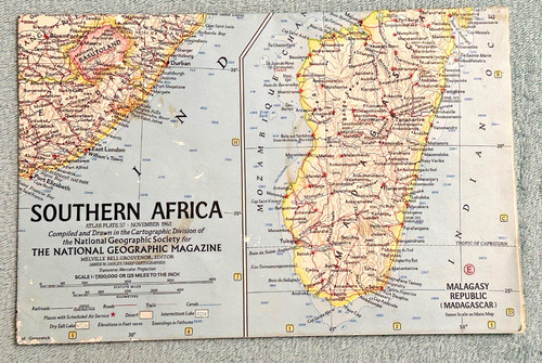
Nov 1962 National Geographic map Southern Africa Angola Congo Uganda Kenya
November 1962 National Geographic map of Southern Africa includes Angola, Republic of Congo, Uganda, Kenya, Tanganyika, Mozambique. (Republic of the Congo) and to the south (Cape of Good Hope) and from the east (Angola) to the west (Mozambique).

VINTAGE AFRICA MAP February 1943 National Geographic
Africa Map National Geographic February 1943 This map is in good condition with no marks or tears. Some folds have been taped for reinforcement. It is 10" x 30". It is a genuine map that was in a National Geographic magazine. 126.

The Peninsula of Mount Sinai Map Observations on the Ground Rev FW Holland 1868
Map from Frederick Whitmore Holland of the Sinai Peninsula. The Peninsula of Mount Sinai Map. Rev FW Holland 1868.

Vintage 1980 Africa Egypt Kenya Nigeria Libia Congo Geographic Map

AFRICA PHYSICAL MAP+ THE HUMAN FOOTPRINT National Geographic September 2005
Africa Physical Map + Africa - The Human Footprint September 2005 This two-sided poster is in mint condition. It is an original map that was in a National Geographic magazine. It is 22" x 24". 116 Terms: Powered by The free listing tool. List your items fast and easy and manage your active items. Powered by The free listing tool. List your items fast and easy and manage your active items. Powered by The free listing tool. List your items fast and easy and manage your active items. Powered by The free listing tool. List your items fast and easy and manage your active items.

Original Vintage Map AFRICA -PICTORIAL MAP -ARTIST POEPPEL - COLONIALISM - 1940s
Designed by: artist Poeppel, most likely around 1940s, during the World War Second. Historical context: rare and previously unrecorded pictorial map of Africa issued by Germany during the World War Second.

VINTAGE THE NILE VALLEY LAND OF PHARAOHS EGYPT MAP National Geographic May 1965
The Nile Valley Map Land of the Pharaohs May 1965 This two-sided poster is in very good condition with no marks or tears. It is an original map that was in a National Geographic magazine. It is 19" x 24". 416.

Black Light Poster: Desert Rider 1970s
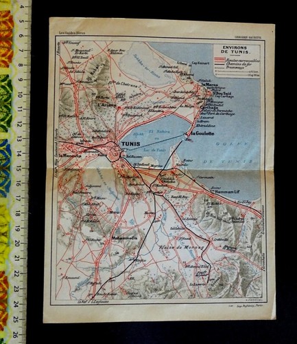
( USA ) , Map of the city of Tunis , Tunisia , Year : 1927 .
Map condition: See scans. Digital images allow you to assess the condition of the maps. All my letters and parcels reach their destination (shipped via economy service). Letters and parcels are carefully packed and protected. Shipping is free worldwide. Best regards, Serge.
AFRICA + ENDANGERED ANIMALS MAP National Geographic December 1990
Africa + Endangered Animals Map December 1990 This two-sided poster is in mint condition. It is an original map that was in a National Geographic magazine. It is 21" x 30". 117 Terms: Powered by The free listing tool. List your items fast and easy and manage your active items. Powered by The free listing tool. List your items fast and easy and manage your active items. Powered by The free listing tool. List your items fast and easy and manage your active items. Powered by The free listing tool. List your items fast and easy and manage your active items.

Pretoria South Africa Vintage Map 1963
This folding map is in very good vintage condition. It is clean and bright with a few light edge marks. A clean solid piece.

2 Vtg National Geographic Maps Peoples Africa Dec 1971 Africa Political Feb 1980

TOURIST MAP OF ETHIOPIA – “LION OF JUDA” PRE-1967 FRENCH SOMALILAND VNTG RARE
Likely pre-1967 issue (Djibouti marked “French Somaliland”), from the Haile Selassie era. Stains, tears at the left, otherwise in good condition.

SOUTHERN AFRICA MAPS - WILDERNESS SAFARIS

National Geographic Vintage Atlas Plate Wall Map August 1966 Northwestern Africa
Map has light use wear. 25" x 19". Let's treat each other with respect and discuss any problems.
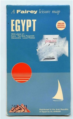
Fairey Liesure Map of Egypt Cairo The Giza Pyramids Alexandria Luxor Thebes
A Fairey Liesure Map of Egypt with plans of ,The Giza Pyramids, Alexandria, Luxor and Thebes. Our Policies.

Vintage Michelin 154 Africa North-East 1: 4000 000 from 1975
In good used condition.
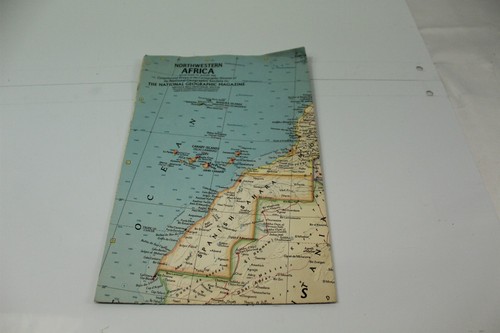
Folded Map Northwestern Africa 1966 National Geographic Society Vintage
collectible map 9-1/2" x 6-1/4" folded 24-7/8" x 19" has been stored and will ship folded br /> estate rescue some smoke odor .
You save $2.10
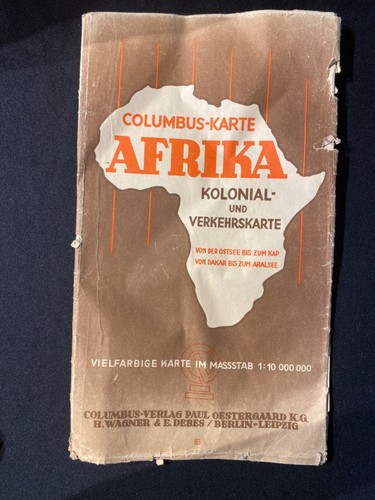
1941 Columbus Karte Afrika Kolonial-Und Verkehrskarte COLUMBUS CARD AFRICA MAP
UND VERKEHRSKARTE. VIELFARBIGE KARTE IM MASSSTAB 1:10 000 000. There is writing on it but I have not verified whether it is a soldier. COLUMBUS CARD. AND TRAFFIC MAP. MULTI-COLORED MAP IN SCALE 1: 10,000,000.

Antique 1896 Central Africa Atlas Map AB
Antique 1896 Central Africa Atlas Map AB. 12" x 9-3/4".

Vintage ABIDJAN Tourist MAP 1973 - Cool Modern Graphic Design - Cote d'Ivoire
Features cool modern graphic design.

1966 National Geographic Map Northwestern Africa Atlas Plate Aug Vintage
National Geographic Magazine Original Map — Northwestern Africa (Aug 1966 Atlas Plate). Region: Northwestern Africa (including coastal & inland nations). National Geographic Magazine inAugust 1966. Atlas Plate: 55.
You save $3.50
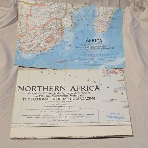
National Geographic Society Africa Map, Washington DC, September 1960
old maps of africa.

1936 Map to Illustrate Treaty of Alliance with Egypt ~ Vintage Original Color UK
Original 1936 map printed and published by His Majesty’s Stationery Office. This is a simple folder with a pocket inside in which the map sits. I didn’t want to flatten the creases too much when taking the photo.

Morocco Map Encyclopedia Britannica Ninth Edition 1880's
A map page removed from Encyclopedia Britannica, Ninth Edition. This map is of the Country of Morocco. It is from Vol. XIV Plate X.

Touring Club of the Belgian Congo Late 1940s Maps and Other Travel Documents

1966-8 National Geographic Map NW NORTHWESTERN AFRICA August
Northwestern Africa Map. Hallmarks: Atlas Plate 55: August 1966.

VINTAGE ALMAX MADRID CIDAD MAP FOR TOURISTS Road Map PLANO, GUIA, CALLEJERO
VINTAGE ALMAX MADRID CIDAD MAP FOR TOURISTS Road Map PLANO, GUIA, CALLEJERO. Bin#64 item#641133
You save $2.80