Maps
maps — pre-owned
Browse 83,606 maps — pre-owned on eBay — listings updated every few minutes. All items are pre-owned and sold by eBay sellers directly.

Excel To Near Mint Unused 1916 Gulf Supreme Auto Oil Road Map New England

Vintage Framed 1992 Kistler 3D Raised Relief Topographical California Map
This map features a detailed depiction of the topography of California, highlighting various features and landmarks.

VERIFIED Original Map NOUVEAU PARIS MONUMENTAL-PLAN OF PARIS-1948-L@@K! RARE!
VERIFIED ORIGINAL 1948 - DIRECT FROM FRANCE.

USGS 1913 San Mateo Quadrangle Geology Map San Francisco Bay California Antique
Original U.S. Geological Survey geological map of the San Mateo Quadrangle, California, issued in October 1913. Original 1913 issue, not a modern reproduction.

Excel To Near Mint Unused 1916 Gulf Supreme Auto Oil Road Map NY New York

Vintage Rand McNally State Maps Lot Travel USA Bundle Road Trip Incomplete
Great display piece or functional travel reference.

COASTAL CALIFORNIA MAP National Geographic July 1993
Coastal California Map Coast Redwoods, San Francisco, Monterrey, Los Angeles, San Diego, Hearst Castle, Golden Gate Bridge, Wine Country July 1993 This two-sided poster is in mint condition. It is an original map that was in a National Geographic magazine. It is 10" x 31". 116 Terms: Powered by The free listing tool. List your items fast and easy and manage your active items. Powered by The free listing tool. List your items fast and easy and manage your active items. Powered by The free listing tool. List your items fast and easy and manage your active items. Powered by

HUGE VINTAGE UNITED STATES MAP + PHOTOMOSAIC MAP National Geographic July 1976
United States Map + Portrait U.S.A. The first color photomosaic of the 48 contiguous united states July 1976 This huge two-sided poster is in very good condition with no marks or tears. It is an original map that was in a National Geographic magazine. It is 28" x 42". 422.

PINNIPEDS + ANTARCTICA SOUTH POLE MAP April 1987 National Geographic
Pinnipeds + Antarctica South Pole Map National Geographic April 1987 This map is in very good condition with no marks or tears. It is 21" x 30". It is a genuine map that was in a National Geographic magazine. 426.

THE TWO KOREAS MAP + THE FORGOTTEN WAR National Geographic July 2003
The Two Koreas Map National Geographic July 2003 This two-sided map is in very good condition with no marks or tears. It is 20" x 31". It is a genuine map that was in a National Geographic magazine. 426.

VINTAGE ATLANTIC OCEAN WALL MAP National Geographic December 1955 Huge
Atlantic Ocean Map December 1955 This huge one-sided poster is in mint condition with no marks or tears. It is an original map that was in a National Geographic magazine. It is 28" x 39". 824 .

VINTAGE 27" X 22" 1984 ROCKVILLE CONNECTICUT GEOLOGICAL SURVEY TOPOGRAPHIC MAP

VINTAGE MAINE WITH THE MARITIME PROVINCES MAP National Geographic March 1975
Maine with the Maritime Provinces Map March 1975 This large two-sided poster is in mint condition with no marks or tears. It is an original map that was in a National Geographic magazine. It is 22" x 35". 316 Terms: Powered by The free listing tool. List your items fast and easy and manage your active items. Powered by The free listing tool. List your items fast and easy and manage your active items. Powered by The free listing tool. List your items fast and easy and manage your active items. Powered by The free listing tool. List your items fast and easy and manage your active items.

Authentic Vintage Paris RATP Metro Map circa 1979, framed
It was obtained directly from the RATP agency in Paris in 1980. It's more noticeable on close inspection, but the overall map is generally in very nice condition.

Pianta di Roma Map of Rome DISEGNATA DA GIAMBATTISTA NOLLI NEL by M. Danesi 1748
It showstypical signs of shelf wear that may include creasing, soft edges, staining, tanning, writing on the pages and/or paper loss.
You save $388.50

Pottawattamie County Iowa 1967 Atlas Council Bluffs Carter Lake Avoca Oakland IA
Pottawattamie County Iowa 1967 Atlas Council Bluffs Carter Lake Avoca Oakland IA

Wilderness Canoe Area Map - Minnesota & Canada, Don Beland’s Canoe Outfitters
Wilderness Canoe Area Map - Minnesota & Canada, Don Beland’s Canoe Outfitters

THE ROMANS + THE ROMAN EMPIRE MAP National Geographic July 1997
The Roman Empire Map National Geographic July 1997 This map is in very good condition with no marks or tears. It is 22" x 34". It is a genuine map that was in a National Geographic magazine. 426.

PHYSICAL MAP OF UNITED STATES + FEDERAL LANDS National Geographic October 1996
Physical Wall Map of the United States + Federal Lands in the Fifty States Map October 1996 This two-sided poster is in very good condition with no marks or tears. It is a genuine map that was in a National Geographic magazine. It is 20" x 32". 824.

VTG VIET NAM, CAMBODIA, LAOS AND THAILAND MAP National Geographic February 1967
Viet Nam, Cambodia, Laos and Thailand Map National Geographic February 1967 This large map is in excellent condition with no marks or tears. It is 31" x 39". It is a genuine map that was in a National Geographic magazine. 521.

VINTAGE CALIFORNIA MAP May 1966 National Geographic
Callifornia Map National Geographic May 1966 This two-sided map is in excellent condition with no marks or tears. It is 15" x 20". It is a genuine map that was in a National Geographic magazine. 423.

WEST INDIES CENTRAL AMERICA CARIBBEAN ISLANDS MAP National Geographic Feb. 1981
Tourist Islands of the West Indies Map February 1981 This two-sided poster is in mint condition with no marks or tears. It is an original map that was in a National Geographic magazine. It is 23" x 36". 116 Terms: Powered by The free listing tool. List your items fast and easy and manage your active items. Powered by The free listing tool. List your items fast and easy and manage your active items. Powered by The free listing tool. List your items fast and easy and manage your active items. Powered by The free listing tool. List your items fast and easy and manage your active items.

HAWAII MAP THE MAKING OF AMERICA+ HISTORY National Geographic November 1983
Hawaii Map The Making of America + History November 1983 This two-sided poster is in mint condition. It is an original map that was in a National Geographic magazine. It is 20" x 28". 316 Terms: Powered by The free listing tool. List your items fast and easy and manage your active items. Powered by The free listing tool. List your items fast and easy and manage your active items. Powered by The free listing tool. List your items fast and easy and manage your active items. Powered by The free listing tool. List your items fast and easy and manage your active items.

THE HISTORY OF THE PHILIPPINES MAP July 1986 National Geographic
The Philippines Map + The History of the Philippines July 1986 This two-sided poster is in very good condition with no marks or tears. It is a genuine map that was in a National Geographic magazine. It is 21" x 28". 224.

VINTAGE WESTERN NEW ENGLAND MAP NH VT MA RI CT National Geographic July 1975
Western New England Map New Hampshire Vermont Massachusetts Rhode Island Connecticut Mountains, seacoast, and a living legacy Close-Up: U.S.A. July 1975 This two-sided poster is in mint condition. It is an original map that was in a National Geographic magazine. It is 22" x 35". 316 Terms: Powered by The free listing tool. List your items fast and easy and manage your active items. Powered by The free listing tool. List your items fast and easy and manage your active items. Powered by The free listing tool. List your items fast and easy and manage your active items. Powered by

NATURAL HAZARDS OF NORTH AMERICA MAP + DISASTERS National Geographic July 1998
Natural Hazards of North America + Great Disasters July 1998 This two-sided poster is in mint condition. It is an original map that was in a National Geographic magazine. It is 20" x 32". 317 Terms: Powered by The free listing tool. List your items fast and easy and manage your active items. Powered by The free listing tool. List your items fast and easy and manage your active items. Powered by The free listing tool. List your items fast and easy and manage your active items. Powered by The free listing tool. List your items fast and easy and manage your active items.
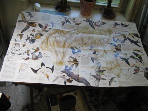
BIRD MIGRATION MAP EASTERN+ WESTERN HEMISPHERE National Geographic April 2004
Bird Migration Map Eastern & Western Hemisphere National Geographic April 2004 This map is in very good condition with no marks or tears. It is 20" x 31". It is a genuine map that was in a National Geographic magazine. 426.

VINTAGE 44" X 23" US DEPT OF COMMERCE HUSON RIVER COXSACKIE TO TROY MAP

1912 USGS Buena Vista Lake California Topographic Map Cloth Backed Bakersfield
Antique United States Geological Survey (USGS) topographic map of the Buena Vista Lake region of California. USGS Topographic Map. This original map covers portions of Kern County, including Buena Vista Lake, Bakersfield, Oil Junction, Waits, and surrounding agricultural and oil-producing areas of the southern San Joaquin Valley.
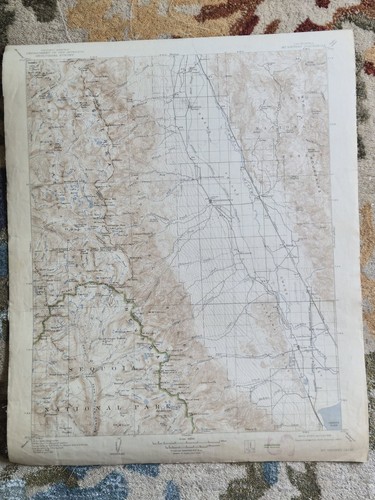
Antique USGS Mount Whitney California Topographic Map 1907 / 1939 Reprint Cloth
Original United States Geological Survey topographic map of the Mount Whitney Quadrangle, California. Mount Whitney Quadrangle. Edition of 1907, reprinted 1939. Original Edition 1907. Reprinted 1939.

Vintage Pull Down School House Map

Black and Yellow Trail Map Huron SD Yellowstone Chicago Foldout 17x22 Vintage
H. L. Kyes, Gen. Mgr., Huron, S.D. . The Black and Yellow Trail Association, based in Huron, South Dakota, was conceived to divert Yellowstone traffic to the cities along its line. Huron, South Dakota.

THE EARTH'S FRACTURED SURFACE EARTHQUAKE FAULTS MAP National Geographic 1995
The Earth's Fractured Surface Map + Living on the Edge - California Fault Lines Map Where Tectonic Plates Meet Seismology April 1995 This two-sided poster is in mint condition. It is an original map that was in a National Geographic magazine. It is 22" x 36". 916 Terms: Powered by The free listing tool. List your items fast and easy and manage your active items. Powered by The free listing tool. List your items fast and easy and manage your active items. Powered by The free listing tool. List your items fast and easy and manage your active items.

THE MAKING OF AMERICA NEW ENGLAND MAP National Geographic February 1987 HISTORY
The Making of America New England Map Political and Historical February 1987 This two-sided poster is in mint condition. It is an original map that was in a National Geographic magazine. It is 20" x 27". 117 Terms: Powered by The free listing tool. List your items fast and easy and manage your active items. Powered by The free listing tool. List your items fast and easy and manage your active items. Powered by The free listing tool. List your items fast and easy and manage your active items. Powered by The free listing tool. List your items fast and easy and manage your active items.

SPAIN IN THE AMERICAS MAP National Geographic February 1992
Spain in the Americas Wall Map + The Grand Exchange February 1992 This two-sided poster is in mint condition. It is an original map that was in a National Geographic magazine. It is 20" x 29". 117 Terms: Powered by The free listing tool. List your items fast and easy and manage your active items. Powered by The free listing tool. List your items fast and easy and manage your active items. Powered by The free listing tool. List your items fast and easy and manage your active items.

THE AMERICAS MAP+PEOPLING OF THE AMERICAS National Geographic December 2000
The Americas Wall Map + Peopling of the Americas December 2000 This two-sided poster is in mint condition. It is an original map that was in a National Geographic magazine. It is 20" x 31". 116 Terms: Powered by The free listing tool. List your items fast and easy and manage your active items. Powered by The free listing tool. List your items fast and easy and manage your active items. Powered by The free listing tool. List your items fast and easy and manage your active items. Powered by The free listing tool. List your items fast and easy and manage your active items.

THE HEAVENS + STAR CHARTS ORION NEBULA MAP National Geographic December 1995
The Heavens + Star Birth in the Orion Nebula Map National Geographic December 1995 This map is in very good condition with no marks or tears. It is 20" x 27". It is a genuine map that was in a National Geographic magazine. 324.

WATER PRECIOUS RESOURCE + UNITED STATES WALL MAP National Geographic 1993
Water Precious Resource + The United States Wall Map November 1993 This huge two-sided poster is in excellent condition with no marks or tears. It is an original poster that was in a National Geographic magazine. It is 43" x 30". 216 Powered by The free listing tool. List your items fast and easy and manage your active items. Powered by The free listing tool. List your items fast and easy and manage your active items. Powered by The free listing tool. List your items fast and easy and manage your active items.

60+ Vintage SINCLAIR Triangle TEXACO Gas OIL Road Maps
Others do not.
You save $120.00
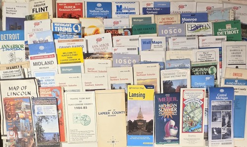
Vintage Michigan Road Maps Lot of 37 Detroit Flint Saginaw Grand Rapids Lansing
You save $6.00