US
us — pre-owned
Browse 64,835 us — pre-owned on eBay — listings updated every few minutes. All items are pre-owned and sold by eBay sellers directly.

Excel To Near Mint Unused 1916 Gulf Supreme Auto Oil Road Map NY New York

USGS 1913 San Mateo Quadrangle Geology Map San Francisco Bay California Antique
Original U.S. Geological Survey geological map of the San Mateo Quadrangle, California, issued in October 1913. Original 1913 issue, not a modern reproduction.

Vintage Framed 1992 Kistler 3D Raised Relief Topographical California Map
This map features a detailed depiction of the topography of California, highlighting various features and landmarks.
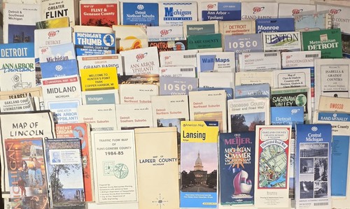
Vintage Michigan Road Maps Lot of 37 Detroit Flint Saginaw Grand Rapids Lansing
You save $6.00

Excel To Near Mint Unused 1916 Gulf Supreme Auto Oil Road Map New England

COASTAL CALIFORNIA MAP National Geographic July 1993
Coastal California Map Coast Redwoods, San Francisco, Monterrey, Los Angeles, San Diego, Hearst Castle, Golden Gate Bridge, Wine Country July 1993 This two-sided poster is in mint condition. It is an original map that was in a National Geographic magazine. It is 10" x 31". 116 Terms: Powered by The free listing tool. List your items fast and easy and manage your active items. Powered by The free listing tool. List your items fast and easy and manage your active items. Powered by The free listing tool. List your items fast and easy and manage your active items. Powered by

HUGE VINTAGE UNITED STATES MAP + PHOTOMOSAIC MAP National Geographic July 1976
United States Map + Portrait U.S.A. The first color photomosaic of the 48 contiguous united states July 1976 This huge two-sided poster is in very good condition with no marks or tears. It is an original map that was in a National Geographic magazine. It is 28" x 42". 422.

Vintage 1950s/60s Hammonds Home Library United States Map 48 States 21x29 USA
Vintage 1950s/60s Hammonds Home Library United States Map 48 States 21 x 29 in. USA. Colorful mid-century educational map published by C.S. Hammond & Co., New York. Features state boundaries, major cities, rivers, and inset maps including Alaska and Hawaii. Original fold-out atlas map with classic classroom and reference library styling. Great for framing, home décor, genealogy research, classroom display, or map collectors. There is a small tear and a couple small holes on the fold creases. See photos for condition and details.

3 NOAA Large Print Maps In Color: Long Island / Block Island / Chesapeake Bay
Chesapeake Bay. -Block Island.

PHYSICAL MAP OF UNITED STATES + FEDERAL LANDS National Geographic October 1996
Physical Wall Map of the United States + Federal Lands in the Fifty States Map October 1996 This two-sided poster is in very good condition with no marks or tears. It is a genuine map that was in a National Geographic magazine. It is 20" x 32". 824.

VINTAGE MAINE WITH THE MARITIME PROVINCES MAP National Geographic March 1975
Maine with the Maritime Provinces Map March 1975 This large two-sided poster is in mint condition with no marks or tears. It is an original map that was in a National Geographic magazine. It is 22" x 35". 316 Terms: Powered by The free listing tool. List your items fast and easy and manage your active items. Powered by The free listing tool. List your items fast and easy and manage your active items. Powered by The free listing tool. List your items fast and easy and manage your active items. Powered by The free listing tool. List your items fast and easy and manage your active items.

THE SOUTHWEST MAP THE MAKING OF AMERICA + HISTORY National Geographic Nov. 1982
The Southwest Map The Making of America + History November 1982 This two-sided poster is in mint condition. It is an original map that was in a National Geographic magazine. It is 21" x 27". 316 Terms: Powered by The free listing tool. List your items fast and easy and manage your active items. Powered by The free listing tool. List your items fast and easy and manage your active items. Powered by The free listing tool. List your items fast and easy and manage your active items. Powered by The free listing tool. List your items fast and easy and manage your active items.

HAWAII MAP THE MAKING OF AMERICA+ HISTORY National Geographic November 1983
Hawaii Map The Making of America + History November 1983 This two-sided poster is in mint condition. It is an original map that was in a National Geographic magazine. It is 20" x 28". 316 Terms: Powered by The free listing tool. List your items fast and easy and manage your active items. Powered by The free listing tool. List your items fast and easy and manage your active items. Powered by The free listing tool. List your items fast and easy and manage your active items. Powered by The free listing tool. List your items fast and easy and manage your active items.

1969 Tom Culverwell Pictorial Map MOUNT DESERT ISLAND Maine Acadia National Park
The 1969 Tom Culverwell Pictorial Map of Mount Desert Island, Maine is a collectible travel guide that showcases the beauty of Acadia National Park. This vintage map captures the essence of the United States, specifically the region of Maine, providing a unique perspective on the natural landscape and landmarks of the area. Created in 1969, this map is a valuable piece of history that serves as a visual record of the beauty and charm of Mount Desert Island and its surroundings.

🧭 VTG 1955 Thomas Bros Popular Atlas Los Angeles County Street Spiral Map Book
(260614) The cover has a nice shine with minor wear from typical handing. Some of the pages have discoloration from age or a light stain. The binding is in good shape. The product is a vintage 1955 Thomas Bros Popular Atlas map book of Los Angeles County in the United States. This spiral-bound map book provides detailed street maps of the region, making it a valuable collectible for those interested in transportation and US maps. The maps likely feature a variety of information such as street names, landmarks, and locations, offering a unique glimpse into the layout and architecture of Los Angeles County from the mid-20th century.
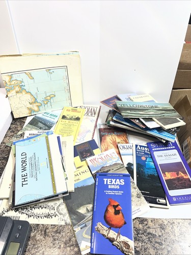
Huge Lot of Vintage Travel Brochures and Maps. 52 Various Pieces. 1980s-1990s

VINTAGE 27" X 22" 1984 ROCKVILLE CONNECTICUT GEOLOGICAL SURVEY TOPOGRAPHIC MAP

VINTAGE 44" X 23" US DEPT OF COMMERCE HUSON RIVER COXSACKIE TO TROY MAP

Vintage Rand McNally State Maps Lot Travel USA Bundle Road Trip Incomplete
Great display piece or functional travel reference.

VINTAGE WESTERN NEW ENGLAND MAP NH VT MA RI CT National Geographic July 1975
Western New England Map New Hampshire Vermont Massachusetts Rhode Island Connecticut Mountains, seacoast, and a living legacy Close-Up: U.S.A. July 1975 This two-sided poster is in mint condition. It is an original map that was in a National Geographic magazine. It is 22" x 35". 316 Terms: Powered by The free listing tool. List your items fast and easy and manage your active items. Powered by The free listing tool. List your items fast and easy and manage your active items. Powered by The free listing tool. List your items fast and easy and manage your active items. Powered by

WATER PRECIOUS RESOURCE + UNITED STATES WALL MAP National Geographic 1993
Water Precious Resource + The United States Wall Map November 1993 This huge two-sided poster is in excellent condition with no marks or tears. It is an original poster that was in a National Geographic magazine. It is 43" x 30". 216 Powered by The free listing tool. List your items fast and easy and manage your active items. Powered by The free listing tool. List your items fast and easy and manage your active items. Powered by The free listing tool. List your items fast and easy and manage your active items.

THE MAKING OF AMERICA NEW ENGLAND MAP National Geographic February 1987 HISTORY
The Making of America New England Map Political and Historical February 1987 This two-sided poster is in mint condition. It is an original map that was in a National Geographic magazine. It is 20" x 27". 117 Terms: Powered by The free listing tool. List your items fast and easy and manage your active items. Powered by The free listing tool. List your items fast and easy and manage your active items. Powered by The free listing tool. List your items fast and easy and manage your active items. Powered by The free listing tool. List your items fast and easy and manage your active items.

VINTAGE GREATER NEW YORK + TOURIST MANHATTAN MAP National Geographic July 1964
Greater New York + Tourist Manhattan Map July 1964 This two-sided poster is in good condition with no tears. There is a name and a library stamp on the outer fold. It is an original map that was in a National Geographic magazine. It is 15" x 20". 426.

Wilderness Canoe Area Map - Minnesota & Canada, Don Beland’s Canoe Outfitters
Wilderness Canoe Area Map - Minnesota & Canada, Don Beland’s Canoe Outfitters
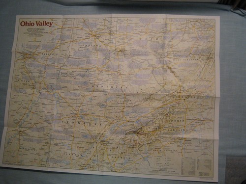
OHIO VALLEY MAP THE MAKING OF AMERICA + HISTORY National Geographic Dec. 1985
Ohio Valley Map The Making of America + History December 1985 This two-sided poster is in mint condition. It is an original map that was in a National Geographic magazine. It is 20" x 28". 316 Terms: Powered by The free listing tool. List your items fast and easy and manage your active items. Powered by The free listing tool. List your items fast and easy and manage your active items. Powered by The free listing tool. List your items fast and easy and manage your active items. Powered by The free listing tool. List your items fast and easy and manage your active items.

VINTAGE NORTH CENTRAL UNITED STATES WALL MAP National Geographic June 1948
North Central United States Map Iowa, Missouri, Kansas, Nebraska, South Dakota, North Dakota, Illinois, Wisconsin, Minnesota June 1948 This large poster is in very good condition with no marks or tears. It is an original map that was in a National Geographic magazine. It is 27" x 28". 1219.

WESTERN MIGRATION + THE PATHFINDERS WALL MAP National Geographic September 2000
Western Migration Dreams of Gold and a Better Life Drive Mass Movement + The Pathfinders Wall Map September 2000 This two-sided poster is in mint condition. It is an original map that was in a National Geographic magazine. It is 22" x 35". 116 Click on the red book icon and check our Ebay store Heart for Ethiopia for more good buys. We have many books and other items. They are arranged in categories. Most are $1 or $2. All proceeds go to Ethiopia to provide for development and child education in rural Ethiopia. Because we are raising money for charity no item will ever be reduced below $1. We give a combined shipping d It is an original map that was in a National Geographic magazine. iscount on all media items. Terms: Powered by The free listing tool.

MANHATTAN NEW YORK CITY COLOR WALL MAP September 1990 National Geographic
Manhattan + New York City Map Special Places of the World September 1990 This two-sided poster is in very good condition with no marks or tears. It is an original map that was in a National Geographic magazine. It is 10" x 31". 824.

Pottawattamie County Iowa 1967 Atlas Council Bluffs Carter Lake Avoca Oakland IA
Pottawattamie County Iowa 1967 Atlas Council Bluffs Carter Lake Avoca Oakland IA

1914 Imperial Valley CA Tract Map Irrigation District Thurston Rock El Centro
Credits: Albert G. Thurston; drawn by Geo. • Type: Folding map / tract map / irrigation map. • Region: United States, California, Imperial County, Imperial Valley.
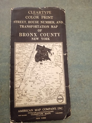
Vintage Bronx Street & House Number Map – Cleartype / American Map Co.-Pre‑1941
Theoriginal cover is intact, and the map is ingood condition for its age. Folds are present as expected, but the interior printing remains clear and readable. Why collectors want this map. Pre‑1941 edition (Hebrew Orphan Asylum still shown).

Outer Banks Map - Ghost Fleet of the Outer Banks, United States (1962) Reprint
Outer Banks Map - Ghost Fleet of the Outer Banks, United States (1962) Reprint

TEXAS MAP THE MAKING OF AMERICA + HISTORY National Geographic March 1986
Texas Map The Making of America + Texas History March 1986 This two-sided poster is in mint condition. It is an original map that was in a National Geographic magazine. It is 21" x 27". 316 Terms: Powered by The free listing tool. List your items fast and easy and manage your active items. Powered by The free listing tool. List your items fast and easy and manage your active items. Powered by The free listing tool. List your items fast and easy and manage your active items. Powered by The free listing tool. List your items fast and easy and manage your active items.

VINTAGE CALIFORNIA & NEVADA MAP CLOSE-UP USA National Geographic June 1974
California and Nevada Map Close-Up U.S.A. Storied realm of glitter and greenery June 1974 This two-sided poster is in mint condition. It is an original map that was in a National Geographic magazine. It is 23" x 34". 316 Terms: Powered by The free listing tool. List your items fast and easy and manage your active items. Powered by The free listing tool. List your items fast and easy and manage your active items. Powered by The free listing tool. List your items fast and easy and manage your active items. Powered by The free listing tool.
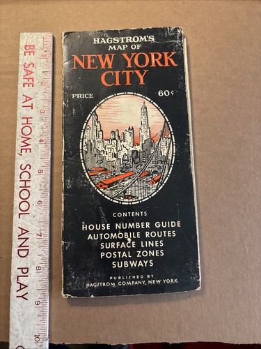
Vintage Map Hagstrom's New York City 1940’s house number guide subway
Vintage Map Hagstrom's New York City 1940’s house number guide subway. Condition is Used. Shipped with USPS Ground Advantage.
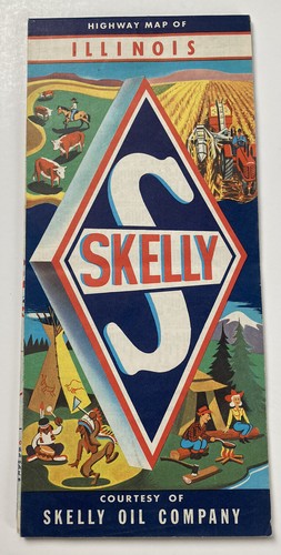
Vintage 1950s Skelly Oil Company Illinois Retro folding Highway Map
With its retro design and United States origin, this map is a unique find that would make a great conversation starter or gift.

REDISCOVERING HAWAII MAP September 1995 National Geographic
Rediscovering Hawaii Map National Geographic September 1995 This map is in mint condition with no marks or tears. It is 19" x 31". It is a genuine map that was in a National Geographic magazine. 419 [Add a map to your own listings. FREE Trial!] (https://applications.ebay.com/selling?ViewEAppDetails&stab=1&appType=1&appId=newage.mystoremaps.com).
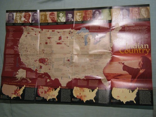
NORTH AMERICAN INDIAN CULTURES+INDIAN COUNTRY MAP National Geographic Sept. 2004
North American Indian Cultures Map + Indian Country September 2004 This two-sided poster is in very good condition with no marks or tears. Some folds have been taped for reinforcement. It is an original map that was in a National Geographic magazine. It is 20" x 31". 1021.

Black and Yellow Trail Map Huron SD Yellowstone Chicago Foldout 17x22 Vintage
H. L. Kyes, Gen. Mgr., Huron, S.D. . The Black and Yellow Trail Association, based in Huron, South Dakota, was conceived to divert Yellowstone traffic to the cities along its line. Huron, South Dakota.

Burning Man Map and Guide Black Rock City 2015 Carnival of Mirrors
Burning Man Map and Guide Black Rock City 2015 Carnival of Mirrors