Canada
canada — pre-owned
Browse 3,387 canada — pre-owned on eBay — listings updated every few minutes. All items are pre-owned and sold by eBay sellers directly.
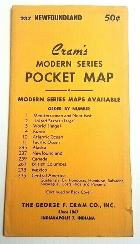
Vintage 1950's Cram's Modern Series Pocket Map #237 Newfoundland Canada
Very good condition overall. Still in Original plastic sleeve. Cover may have slight edge and/or corner wear. If you find a number of things you are interested in.
You save $1.29

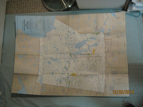
13 Vintage Canada Travel Maps Guides British Columbia Alberta Quebec Montreal
Includes publications covering: British Columbia / Victoria, Alberta / Calgary, Saskatchewan / Saskatoon / Regina, Quebec / Montreal. Calgary fold-out map is more worn from use. The Pacific 66 map has a small cover tear, and one duplicate Saskatoon map was folded incorrectly.

Vintage 1998 CHS Nautical Chart 3673 Clayoquot Sound Tofino Inlet BC Canada Map
Clayoquot Sound, Vancouver Island, British Columbia, Canada. Tofino Inlet to / à Millar Channel. This is Chart#3673, beautifully detailed and scale-mapped at1:40,000, showcasing the stunning waterways ofClayoquot Sound on Vancouver Island, British Columbia.
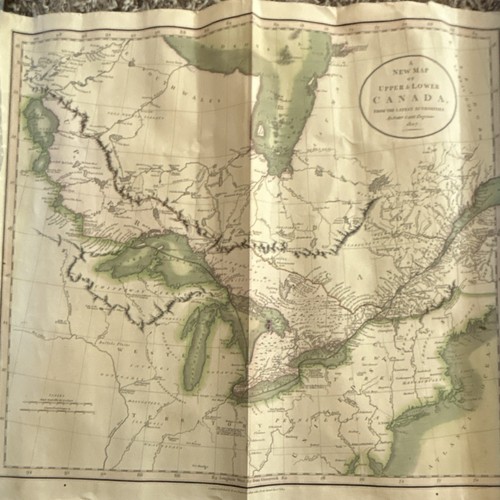
John Cary Map of Upper & Lower Canada 1807 Antique Canadian Map
The John Cary Map of Upper & Lower Canada from 1807 is an antique Canadian map that offers a glimpse into the past of the region. This historical map provides valuable insights into the geography and landmarks of Canada during that time period, making it a valuable collectible for enthusiasts of Canadian history and cartography. With detailed cartography and a focus on Upper & Lower Canada, this map allows viewers to explore the transportation networks and unique features of the region in the early 19th century.

Ville de Grand-Mere, Québec 1994 edition map/carte/guide
Originating from Canada, this map is a valuable historical piece for those interested in exploring the area's past and present features. En tres bonne condition.

1967 Montreal Map Expo67
1967 Montreal Map Expo67. It is in very good condition. We combine shipping whenever possible. Please email us to request shipping quote for multiple item purchases before buying. Local Pick-up available please email a request prior to purchase.
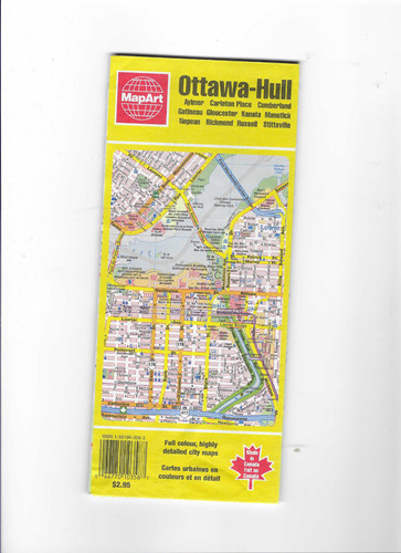
Ottawa-Hull and Area 1996 edition map, MapArt Publishing
The Ottawa-Hull and Area 1996 edition map by MapArt Publishing is a detailed and accurate map of the Ottawa-Hull region in Canada. Published in 1996, this map is a collectible piece that showcases the transportation networks and landmarks of the area.

PRAIRIE PROVINCES MAP THE MAKING OF CANADA National Geographic December 1994
Prairie Provinces Map Alberta, Saskatchewan, Manitoba History & Natural Resources The Making of Canada December 1994 This two-sided poster is in mint condition. It is an original map that was in a National Geographic magazine. It is 20" x 27". 117 Terms: Powered by The free listing tool. List your items fast and easy and manage your active items. Powered by The free listing tool. List your items fast and easy and manage your active items. Powered by The free listing tool. List your items fast and easy and manage your active items. Powered by The free listing tool.

Vtg Canada Vermillion Minnitaki Lake 24x31 Paper Fishing Map Moosehorn Lodge
Features the Vermillion, Pelican, and Minnitaki Lakes in Ontario, Canada. Advertises for the Moosehorn Lodge.

Superior-Quetico Wilderness Canoe Area Map Reached From Canadian Waters 1964
Superior-Quetico Wilderness Canoe Area Map Reached From Canadian Waters 1964

VINTAGE CENTRAL CANADA MAP National Geographic July 1963
Central Canada Map July 1963 This one-sided poster is in mint condition. It is an original map that was in a National Geographic magazine. It is 19" x 25". 616 Terms: Powered by The free listing tool. List your items fast and easy and manage your active items. Powered by The free listing tool. List your items fast and easy and manage your active items. Powered by The free listing tool. List your items fast and easy and manage your active items. Powered by The free listing tool. List your items fast and easy and manage your active items.
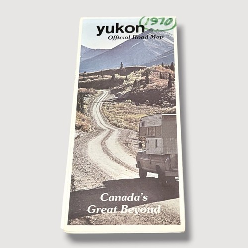
Yukon Official Road Map Canada 1970 Vintage HX
Yukon Official Road Map Canada 1970 Vintage HX

ATLANTIC CANADA MAP THE MAKING OF CANADA National Geographic October 1993
Atlantic Canada Wall Map Quebec, Newfoundland, Labrador, New Brunswick, Nova Scotia History & Natural Resources The Making of Canada October 1993 This two-sided poster is in mint condition. It is an original map that was in a National Geographic magazine. It is 20" x 27". 116 Terms: Powered by The free listing tool. List your items fast and easy and manage your active items. Powered by The free listing tool. List your items fast and easy and manage your active items. Powered by The free listing tool. List your items fast and easy and manage your active items. Powered by

Vintage Ontario & New York Map + 1930 Ontario Census Data – Double‑Sided
Original mid‑century double‑sided atlas plate featuring a full color map of Ontario and New York on one side, and detailed 1930 Ontario census information on the reverse. Ideal for collectors, historians, genealogists, and framing.

Vintage Four Superior Quetico Canoe / Lakes Maps, No 104
No 104. Shows wear. Awesome map though from 1952. Just don’t make stuff with this material anymore.

10 Vtg. Atlantic Canada Travel Guides Maps Nova Scotia PEI Newfoundland Halifax
These publications date to 1957 or thereabouts, with matching period artwork and graphics throughout.

1938 Province of Ontario Map 56a Quetico Provincial Park, Canada
1938 Province of Ontario Map 56a Quetico Provincial Park, Canada

CANADA MAP + CANADA'S VACATIONLANDS National Geographic November 1985
Canada Map + Canada's Vacationlands November 1985 This two-sided poster is in mint condition. It is an original map that was in a National Geographic magazine. It is 22" x 34". 316 Terms: Powered by The free listing tool. List your items fast and easy and manage your active items. Powered by The free listing tool. List your items fast and easy and manage your active items. Powered by The free listing tool. List your items fast and easy and manage your active items. Powered by The free listing tool. List your items fast and easy and manage your active items.

QUEBEC WALL MAP THE MAKING OF CANADA National Geographic March 1991
Prairie Provinces Map Alberta, Saskatchewan, Manitoba History & Natural Resources The Making of Canada December 1994 This two-sided poster is in mint condition. It is an original map that was in a National Geographic magazine. It is 20" x 27". 116 Terms: Powered by The free listing tool. List your items fast and easy and manage your active items. Powered by The free listing tool. List your items fast and easy and manage your active items. Powered by The free listing tool. List your items fast and easy and manage your active items. Powered by The free listing tool.

1970 Canada Highway Map and Northern United States
This collectible item is a valuable piece of transportation history, showcasing the geography and major highways of Canada and the northern United States during that era.

Ontario Official Road Map Canada - Ontario Canada Official Road Map
Ontario Official Road Map Canada - Ontario Canada Official Road Map
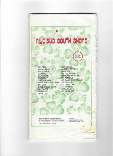
South Shore/Rive Sud de Montreal map/carte d'époque 1984 des Municipalités
Map of Dougherty Advertising. Map complete et peut avoir quelques petites déchurures. Map de Dougherty Advertising.

YUKON & NORTHWEST TERRITORY MAP National Geographic September 1997 MAKING CANADA
Yukon and Northwest Territories Wall Map The Making of Canada + The North September 1997 This two-sided poster is in mint condition. It is an original map that was in a National Geographic magazine. It is 20" x 27". 816 Terms: Powered by The free listing tool. List your items fast and easy and manage your active items. Powered by The free listing tool. List your items fast and easy and manage your active items. Powered by The free listing tool. List your items fast and easy and manage your active items. Powered by The free listing tool.

Lot of Maps and Brochures of British Columbia Canada Vancouver Island Victoria
Including Vancouver Island, Victoria, Cowichan and Alberta. of British Columbia Canada.

1962 La Province de Quebec Canada Map French & English
A 1962 La Province de Quebec Map in French & English. In very good condition. Our Policies.

Ontario Official Road Map & Quetico Provincial Park Map 56a Canada
Ontario Official Road Map & Quetico Provincial Park Map 56a Canada

VINTAGE CANADA MAP National Geographic December 1961
Canada Map December 1961 This one-sided poster is in very good condition with no marks or tears. It is an original map that was in a National Geographic magazine. It is 19" x 25". 124.

CLOSE-UP CANADA QUEBEC AND NEWFOUNDLAND MAP National Geographic May 1980
Close-Up Canada Map Quebec and Newfoundland Where east is l'est and lands end looms May 1980 This two-sided poster is in mint condition. It is an original map that was in a National Geographic magazine. It is 23" x 29". 316 Terms: Powered by The free listing tool. List your items fast and easy and manage your active items. Powered by The free listing tool. List your items fast and easy and manage your active items. Powered by The free listing tool. List your items fast and easy and manage your active items. Powered by The free listing tool.

Vtg Esso Canada Travel Maps Brochures 1964-1974 Provinces Imperial Oil Lot of 5
Atlanta Provinces, Alberta and British Columbia, Quebec, Manitoba Saskatchewan, Ontario, Canada.

British Columbia Canada 1970's/early 80's Travel Brochures Postcards Pix Map LOT
See photos for all that's included.
You save $4.29

1953 Hither & Tither in New Brunswick Canada Travel Guide & Road Map. A
1953 Hither & Tither in New Brunswick Canada Travel Guide & Road Map

Vintage Maps And Travel Guides To Canada Lot Of 8
All vintage from the early 70s from what I can see, really nice condition, ready to take a trip down memory lane!
You save $9.00
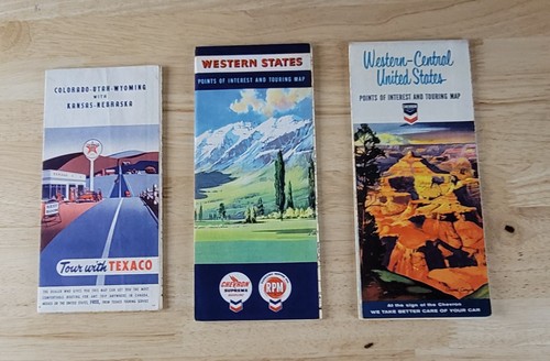
Vintage 1950s/60s WESTERN STATES MAPS Lot of 3 Chevron & Texaco
CHEVRON - TEXACO. TOUR WITH TEXACO - COLORADO - UTAH - WYOMING - KANSAS - NEBRASKA - WEAR ON THE EDGES OF THE MAP. THERE IS A FAINT CREASE ON THE COVER. THERE ARE NO MARKINGS, STAINS OR TEARS. CHEVRON - WESTERN - CENTRAL UNITED STATES - MINOR WEAR ON THE EDGES.
You save $5.00

Western Canada Road Map Courtesy of Mobil 1973 Edition (88) (YG)
As shown in photos.
You save $2.97

VINTAGE WESTERN CANADA WALL MAP National Geographic September 1966
Western Canada Map September 1966 This one-sided poster is in mint condition. It is an original map that was in a National Geographic magazine. It is 19" x 25". 316 Terms: Powered by The free listing tool. List your items fast and easy and manage your active items. Powered by The free listing tool. List your items fast and easy and manage your active items. Powered by The free listing tool. List your items fast and easy and manage your active items. Powered by The free listing tool. List your items fast and easy and manage your active items.

Northwest Territories Canada Vintage Official Explorer's Travel Arctic Map 1984

VINTAGE 1959 WHITE ROSE CANADIAN OIL CO. ROAD MAP EXCELLENT
SEE PHOTOS.
CANADA SASKATCHEWAN MANITOBA NW TERRITORIES MAP National Geographic May 1979
Close-Up: Canada Saskatchewan Manitoba Northwest Territories Map + History of Growth Midlands and a Medley of People May 1979 This two-sided poster is in mint condition. It is an original map that was in a National Geographic magazine. It is 22" x 31". 117 Terms: Powered by The free listing tool. List your items fast and easy and manage your active items. Powered by The free listing tool. List your items fast and easy and manage your active items. Powered by The free listing tool. List your items fast and easy and manage your active items. Powered by The free listing tool.
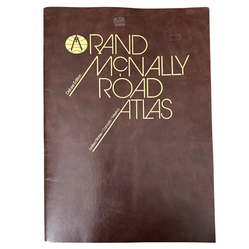
Original Rand McNally Road Atlas Deluxe Edition US/Canada/Mexico Large 1984
In excellent condition, large maps

Canada Principal Mineral Areas Map 900A Seventh Edition 1956
Canada Principal Mineral Areas Map 900A Seventh Edition 1956